| Mesoscale Discussion 290 | |
| < Previous MD | |

|
|
   Mesoscale Discussion 0290
   NWS Storm Prediction Center Norman OK
   0337 PM CDT Tue Mar 24 2026

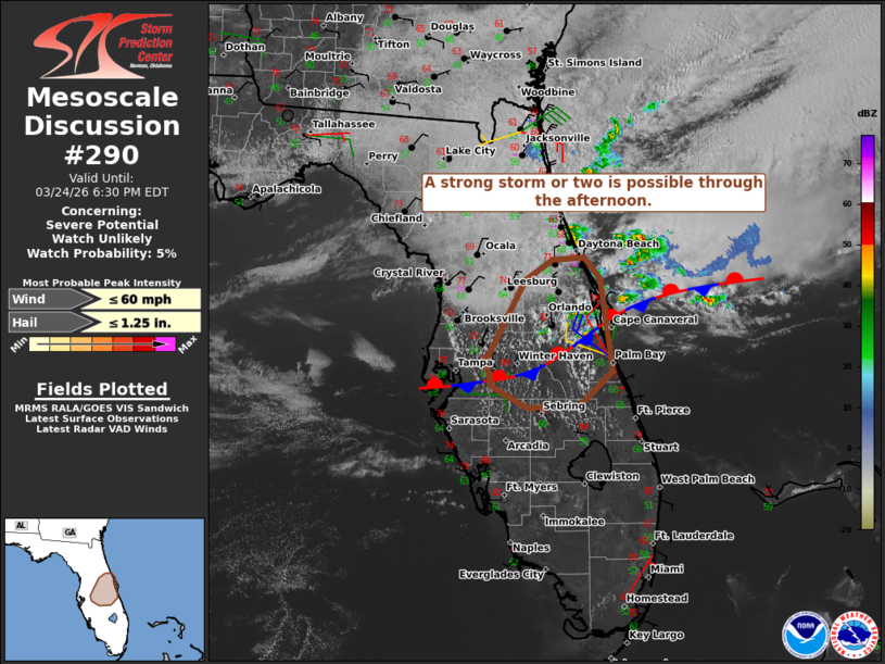
   Areas affected...Parts of the central Florida Peninsula

   Concerning...Severe potential...Watch unlikely

   Valid 242037Z - 242230Z

   Probability of Watch Issuance...5 percent

   SUMMARY...A strong storm or two may pose a risk of marginally severe
   hail (around 1 inch in diameter) and locally damaging gusts through
   the afternoon.

   DISCUSSION...Isolated thunderstorms are evolving at the intersection
   of an east/west-oriented front and the sea breeze in parts of
   central FL this afternoon. Here, ample diurnal heating amid
   middle/upper 60s dewpoints and relatively steep midlevel lapse rates
   (per recent MCO ACARS sounding) has contributed to enough buoyancy
   for a strong storm or two. While low-level flow is weak, around
   25-30 kt of midlevel flow (per MLB VWP and the ACARS sounding) may
   favor brief storm organization. Marginally severe hail and locally
   damaging gusts cannot be ruled out with the stronger cores. The
   overall severe-storm risk is expected to remain localized and
   marginal.

   ..Weinman/Hart.. 03/24/2026

   ...Please see www.spc.noaa.gov for graphic product...

   ATTN...WFO...MLB...TBW...

   LAT...LON   27788203 28048209 28908162 29118130 29138092 28928073
               27938058 27588096 27558161 27788203

   MOST PROBABLE PEAK WIND GUST...UP TO 60 MPH
   MOST PROBABLE PEAK HAIL SIZE...UP TO 1.25 IN
|
|
|
Top/All Mesoscale Discussions/Forecast Products/Home |
|
Source link


