| Mesoscale Discussion 284 | |
| < Previous MD | |
|
|
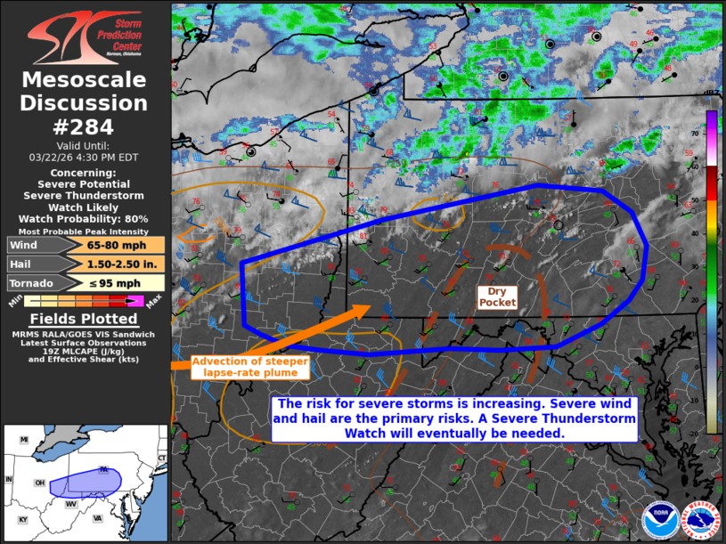
   Mesoscale Discussion 0284
   NWS Storm Prediction Center Norman OK
   0202 PM CDT Sun Mar 22 2026

   Areas affected...portions of southeastern Ohio into central
   Pennsylvania...northern West Virginia...and western Maryland

   Concerning...Severe potential...Severe Thunderstorm Watch likely

   Valid 221902Z - 222030Z

   Probability of Watch Issuance...80 percent

   SUMMARY...The risk for severe thunderstorms is increasing.
   Supercells and small bowing segments will support a severe wind/hail
   risk through the afternoon. A tornado is also possible. A Severe
   Thunderstorm watch will eventually be needed.

   DISCUSSION...Visible satellite imagery depicts a gradual deepening
   of cumulus on the southern periphery of a cloud deck, and ahead of
   an approaching cold front, where surface temperatures have warmed
   above 80 F. Surface dewpoints range from the upper 40s to mid 50s F,
   resulting in meager buoyancy (i.e. 1000 J/kg SBCAPE per the 18Z PIT
   observed sounding). Despite relatively poor moisture, steep
   tropospheric lapse rates and enlarged hodographs (per recent CCX/PBZ
   VADs), will support the development of potentially longer-lived
   updrafts with any storms that manage to mature. Supercells and small
   bowing segments are possible. 50+ kts of effective bulk shear amid
   7.5-8.5 C/km 700-500 mb lapse rates will support severe hail
   potential with sustained supercells, with some stones potentially
   reaching 2 inches in diameter. Furthermore, given the well-mixed
   boundary layer and strong speed shear in place (per 18Z PIT observed
   sounding), efficient damaging wind production is possible. A gust or
   two may exceed 65 kts.

   Storms are expected to initiate in the next few hours, so a Severe
   Thunderstorm Watch will eventually be needed.

   ..Squitieri/Mosier.. 03/22/2026

   ...Please see www.spc.noaa.gov for graphic product...

   ATTN...WFO...CTP...LWX...PBZ...RLX...

   LAT...LON   40268195 40748003 41097790 41037701 40797661 40447643
               40097649 39877669 39637706 39407768 39387845 39397911
               39338019 39368087 39418132 39518167 39608189 40268195

   MOST PROBABLE PEAK TORNADO INTENSITY...UP TO 95 MPH
   MOST PROBABLE PEAK WIND GUST...65-80 MPH
   MOST PROBABLE PEAK HAIL SIZE...1.50-2.50 IN
|
|
|
Top/All Mesoscale Discussions/Forecast Products/Home |
|
Source link