| Mesoscale Discussion 283 | |
| < Previous MD | |
|
|
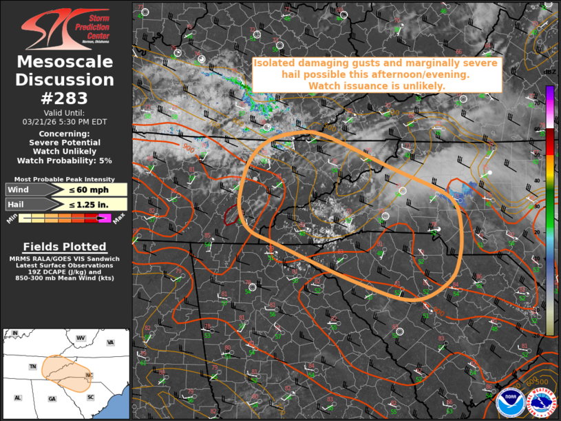
   Mesoscale Discussion 0283
   NWS Storm Prediction Center Norman OK
   0231 PM CDT Sat Mar 21 2026

   Areas affected...the Southern Appalachians into the Carolinas

   Concerning...Severe potential...Watch unlikely

   Valid 211931Z - 212130Z

   Probability of Watch Issuance...5 percent

   SUMMARY...Isolated to widely scattered thunderstorms may pose a
   threat for occasional damaging wind gusts and marginally severe hail
   this afternoon/evening. Watch issuance is unlikely.

   DISCUSSION...Latest regional surface analysis depicts surface
   dewpoints in the upper-40s to low-50s F amid deep, well-mixed
   boundary layer profiles. Despite this limited low-level moisture,
   cool temperatures and steep lapse rates in the mid-levels are
   helping to support weak buoyancy, with latest mesoanalysis
   indicating the presence of 500-750 J/kg MLCAPE across portions of
   Middle and eastern Tennessee. As modest ascent increases ahead of an
   approaching mid-level trough and convective temperatures are reached
   over the next few hours, isolated to widely scattered thunderstorm
   development is expected across the southern Cumberland and Blue
   Ridge Mountains. While mid/upper level flow will remain weak to
   modest (effective bulk shear of only 25-30 kts), some limited storm
   organization is possible. Marginally severe hail may accompany the
   strongest cores amid an initially cellular storm mode. With time, a
   gradual evolution toward a more linear/line segment mode is then
   expected as storms move east-southeastward. Steep low-level lapse
   rates (8.5+ C/km) and DCAPE of 600-900 J/kg (locally higher) will
   support the potential for isolated strong to damaging wind gusts.
   The onset of nocturnal boundary-layer stabilization should then
   result in a decreasing severe threat later this evening as the
   storms move into the coastal Carolinas.

   ..Chalmers/Leitman.. 03/21/2026

   ...Please see www.spc.noaa.gov for graphic product...

   ATTN...WFO...RNK...CAE...GSP...MRX...JKL...FFC...

   LAT...LON   35508468 35828467 36248453 36568421 36708366 36668308
               36168178 35828091 35608060 35278052 34838053 34418075
               34138143 34408249 34988395 35198450 35508468

   MOST PROBABLE PEAK WIND GUST...UP TO 60 MPH
   MOST PROBABLE PEAK HAIL SIZE...UP TO 1.25 IN
|
|
|
Top/All Mesoscale Discussions/Forecast Products/Home |
|
Source link