| Mesoscale Discussion 267 | |
| < Previous MD | |

|
|
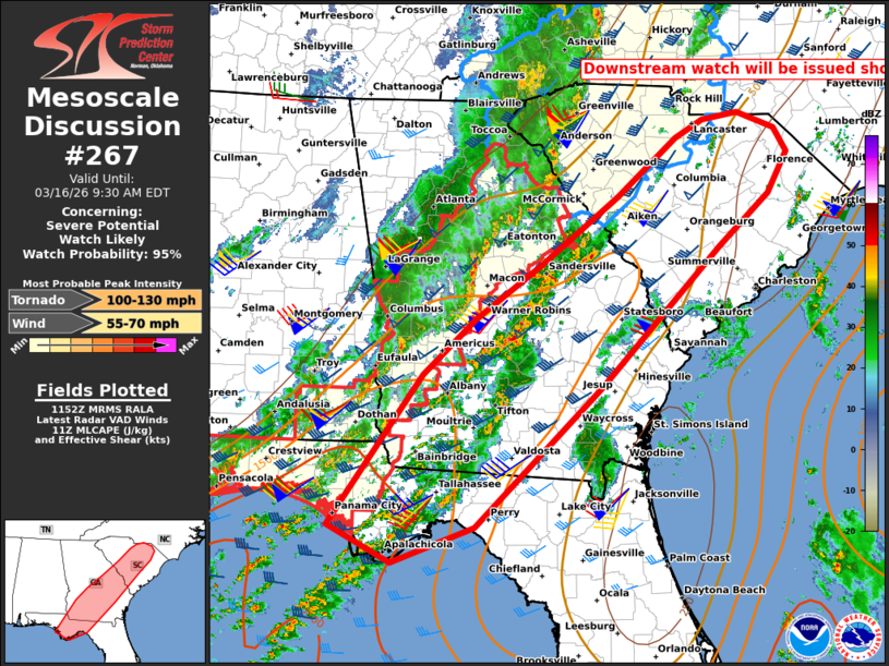
   Mesoscale Discussion 0267
   NWS Storm Prediction Center Norman OK
   0659 AM CDT Mon Mar 16 2026

   Areas affected...Parts of South Carolina...southern/central
   Georgia...and the Florida Panhandle

   Concerning...Severe potential...Watch likely

   Valid 161159Z - 161330Z

   CORRECTED FOR GRAPHIC

   Probability of Watch Issuance...95 percent

   SUMMARY...The risk of damaging wind gusts and a few tornadoes will
   continue spreading eastward across South Carolina, Georgia, and the
   Florida Panhandle. A downstream watch will be issued shortly.

   DISCUSSION...A broken line of thunderstorms is tracking eastward
   toward the edge of WWs 63 and 64, with additional development ahead
   of the line. The downstream environment remains favorable for severe
   thunderstorms with a risk of damaging wind gusts and tornadoes. For
   additional details on this risk, reference Mesoscale Discussion 266.
   A new downstream watch will be issued shortly.

   ..Weinman/Hart.. 03/16/2026

   ...Please see www.spc.noaa.gov for graphic product...

   ATTN...WFO...RAH...ILM...CHS...CAE...GSP...JAX...FFC...TAE...

   LAT...LON   33098285 33868180 34558099 34758062 34848012 34657961
               34377945 33887972 33288040 31658203 30018375 29598488
               30038574 31798447 32438376 33098285

   MOST PROBABLE PEAK TORNADO INTENSITY...100-130 MPH
   MOST PROBABLE PEAK WIND GUST...55-70 MPH
|
|
|
Top/All Mesoscale Discussions/Forecast Products/Home |
|
Source link