| Mesoscale Discussion 253 | |
| < Previous MD | |
|
|
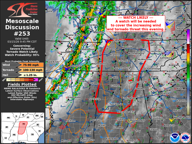
   Mesoscale Discussion 0253
   NWS Storm Prediction Center Norman OK
   0739 PM CDT Sun Mar 15 2026

   Areas affected...southern Kentucky...Middle Tennessee...northern
   Alabama

   Concerning...Severe potential...Tornado Watch likely

   Valid 160039Z - 160245Z

   Probability of Watch Issuance...95 percent

   SUMMARY...Damaging wind and tornado threat to increase through the
   late evening. A Tornado Watch will likely be needed by 02z.

   DISCUSSION...Moisture is steadily increasing into northern Alabama
   and Middle Tennessee this evening as the low-level jet strengthens
   ahead of a broken line of severe convection to the west. Mid to
   upper 50s dew points now extend to the TN/AL/MS border, with a
   narrow axis of 500-1000 J/kg of MLCAPE nosing into northern
   Alabama/Middle Tennessee. This trend in increasing moisture and
   destabilization will continue as the upper level trough moves
   eastward and storms continue to develop near the cold front and
   within the warm sector. The RAP forecast suggests MLCAPE around
   500-1000 J/kg will overlap deep layer shear 40-60 kts from Middle
   Tennessee into northern Alabama. Though the northern extent of the
   instability will be less, the strong background wind environment
   will continue to support a mixed mode of clusters and semi-discrete
   supercells capable damaging wind and tornadoes. A downstream Tornado
   Watch will likely by 02z.

   ..Thornton/Smith.. 03/16/2026

   ...Please see www.spc.noaa.gov for graphic product...

   ATTN...WFO...MRX...LMK...OHX...BMX...HUN...MEG...JAN...

   LAT...LON   32878820 33418844 34458814 35088804 35978797 36598765
               36668649 36638562 36608506 36558502 35968496 34978561
               34128583 33268622 32818690 32878820

   MOST PROBABLE PEAK TORNADO INTENSITY...100-130 MPH
   MOST PROBABLE PEAK WIND GUST...75-90 MPH
   MOST PROBABLE PEAK HAIL SIZE...UP TO 1.25 IN
|
|
|
Top/All Mesoscale Discussions/Forecast Products/Home |
|
Source link