| Mesoscale Discussion 250 | |
| < Previous MD | |
|
|
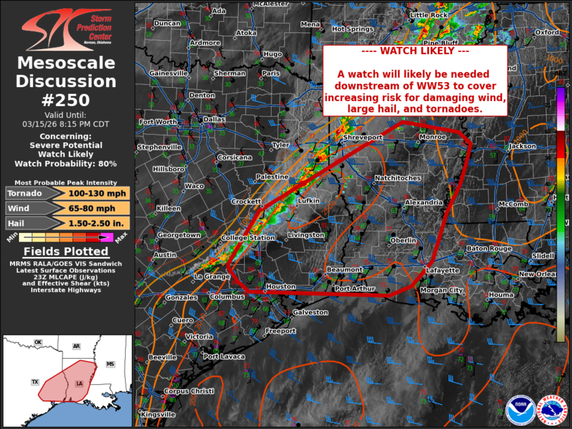
   Mesoscale Discussion 0250
   NWS Storm Prediction Center Norman OK
   0611 PM CDT Sun Mar 15 2026

   Areas affected...portions of far southeastern Texas...central
   Louisiana...eastern Mississippi

   Concerning...Severe potential...Watch likely

   Valid 152311Z - 160115Z

   Probability of Watch Issuance...80 percent

   SUMMARY...Thunderstorm activity is increasing in coverage and
   intensity this evening. Supercells capable of large hail, damaging
   wind, and a couple of tornadoes.

   DISCUSSION...Thunderstorm activity is increasing along the cold
   front moving east across far eastern TX into western LA. Comparison
   of 18z to 20z sounding from SHV showed lifting of the MLCIN layer
   between 850 and 700mb with the influence of the trough moving
   eastward. Though some MLCIN remains across southeast Texas into
   central Louisiana, the environment ahead of these storms is
   characterized by MLCAPE around 1500-2000 J/kg and deep layer shear
   around 40-45 kts. Cooling aloft will continue to erode MLCIN through
   time this evening. This environment will support line embedded
   supercells, capable of damaging wind, large hail, and couple of
   tornadoes. Storms to the north have a history of 1-1.5 inch hail and
   winds up to 65 mph. A new watch will be needed to cover this threat
   over the next couple of hours.

   ..Thornton/Smith.. 03/15/2026

   ...Please see www.spc.noaa.gov for graphic product...

   ATTN...WFO...JAN...LIX...LCH...SHV...HGX...

   LAT...LON   30259614 31229551 32779263 32869244 32849229 32679122
               32459098 32099109 31719122 31209153 30329184 29879229
               29699276 29749570 29949593 30189613 30259614

   MOST PROBABLE PEAK TORNADO INTENSITY...100-130 MPH
   MOST PROBABLE PEAK WIND GUST...65-80 MPH
   MOST PROBABLE PEAK HAIL SIZE...1.50-2.50 IN
|
|
|
Top/All Mesoscale Discussions/Forecast Products/Home |
|
Source link