| Mesoscale Discussion 243 | |
| < Previous MD Next MD > | |
|
|
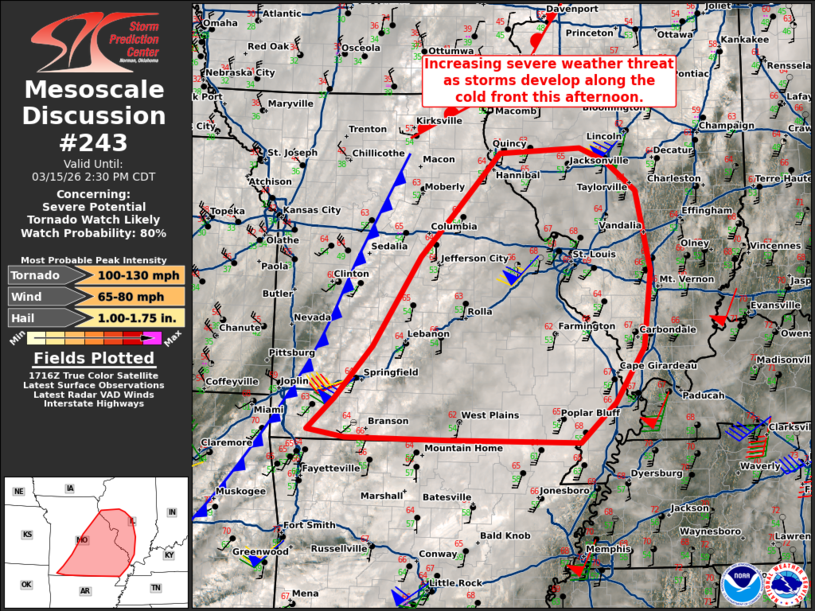
   Mesoscale Discussion 0243
   NWS Storm Prediction Center Norman OK
   1223 PM CDT Sun Mar 15 2026

   Areas affected...central and eastern Missouri into southwest
   Illinois.

   Concerning...Severe potential...Tornado Watch likely

   Valid 151723Z - 151930Z

   Probability of Watch Issuance...80 percent

   SUMMARY...Severe weather potential will increase over the next 1 to
   2 hours as storms develop along the cold front this afternoon.

   DISCUSSION...A 992mb surface low was analyzed across northeast
   Missouri at 17Z with a strong cold front extending southwestward
   across Missouri and into northeast Oklahoma. Ahead of this front,
   low-level moisture advection has brought low to mid 50s dewpoints
   across much of Missouri with some low 60s dewpoints across eastern
   Oklahoma and western Arkansas. This has resulted in around 500 J/kg
   MLCAPE across southern Missouri into parts of central Missouri.
   Strong inhibition from 12Z RAOB at KSGF has eroded substantially on
   the 17Z sounding with the warm nose being lifted 5000 feet in 5
   hours. The combination of this continued ascent and
   warming/moistening low-levels should completely erode inhibition and
   permit strong storm development along the front within the next 1 to
   2 hours. Shortly after initiation, the 500mb jet streak, the nose of
   which can be seen on water vapor imagery across Oklahoma, will
   emerge across the Midwest with strengthening mass response, wind
   fields, and forcing. This will result in a favorable environment for
   strong winds along the front this afternoon and into the early
   evening.

   In addition to the severe wind gust threat, a QLCS tornado threat is
   also anticipated, especially later this afternoon into this evening
   near the Mississippi River. Low-level moisture will likely be the
   primary factor which will impact the tornado threat. Based on
   forecast soundings, upper 50s to near 60 dewpoints will likely
   result in a mostly damaging wind threat, but 62-63F dewpoints would
   likely support a more substantial QLCS tornado threat. This seems
   most likely after 22Z across southeast Missouri and perhaps into far
   southern Illinois per the 15Z HRRR.

   Multiple tornado watches will likely be needed this afternoon to
   address the evolving threat.

   ..Bentley/Gleason.. 03/15/2026

   ...Please see www.spc.noaa.gov for graphic product...

   ATTN...WFO...PAH...ILX...MEG...LSX...SGF...

   LAT...LON   36619409 36999368 37609314 38669243 39199192 39909126
               39969005 39818966 39458921 38508899 37598910 36948954
               36489006 36519204 36529353 36619409

   MOST PROBABLE PEAK TORNADO INTENSITY...100-130 MPH
   MOST PROBABLE PEAK WIND GUST...65-80 MPH
   MOST PROBABLE PEAK HAIL SIZE...1.00-1.75 IN
|
|
|
Top/All Mesoscale Discussions/Forecast Products/Home |
|
Source link