| Mesoscale Discussion 240 | |
| < Previous MD | |

|
|
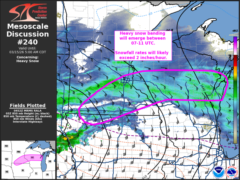
   Mesoscale Discussion 0240
   NWS Storm Prediction Center Norman OK
   1155 PM CDT Sat Mar 14 2026

   Areas affected...Far northwest Iowa...southern Minnesota...and
   central Wisconsin

   Concerning...Heavy snow

   Valid 150455Z - 151000Z

   SUMMARY...Heavy snow banding will become more prominent in the
   coming hours across extreme northwest Iowa, southern Minnesota, and
   into central Wisconsin. Snowfall rates will likely exceed 2 inches
   per hour within a narrow band across the region.

   DISCUSSION...An intensifying cyclone is apparent in surface
   observations over the central Plains as a prominent upper-level jet
   continues to push southeast. Recent VWP observations across the
   eastern Plains have shown a pronounced increase in low-level winds
   (upwards of 50-60 knots at 1 km AGL) within the developing warm
   conveyor belt of the emerging cyclone. Concurrently, an increase in
   precipitation is noted from southwest NE into southeast SD as the
   strengthening low-level winds augment isentropic ascent as well as
   low to mid-level frontogenesis.

   In the coming hours, strong isentropic ascent and more focused lift
   within the frontogenetical circulation between 850-700 mb will shift
   east/northeast into southern MN and central WI as the surface
   cyclone begins to migrate east/northeast. Ascent through a deep
   layer, including through a somewhat shallow dendritic growth zone,
   will support a broad swath of heavy snowfall rates in excess of 1
   inch/hour.

   A combination of focused ascent within a frontogenetical 700 mb
   deformation zone and periodic convective augmentation (8.8 C/km
   mid-level lapse rates were noted in an upstream 00z OAX sounding and
   should be advecting into the southern flank of the deformation zone)
   will likely result in a narrow corridor of snowfall rates between
   2-3 inches/hour. Based on a consensus of recent guidance, this band
   will most likely emerge across southern MN into central WI during
   the 07-11 UTC time frame and will likely persist well into the
   mid-morning hours.

   ..Moore.. 03/15/2026

   ...Please see www.spc.noaa.gov for graphic product...

   ATTN...WFO...MQT...GRB...DLH...ARX...MPX...DMX...FSD...

   LAT...LON   45338876 45318807 45178757 45028729 44778720 44338741
               44068759 44078813 44149025 44169073 44049130 43519322
               43169443 43079499 43159547 43409578 43699585 43969558
               44469481 44809414 45149324 45339221 45389097 45338876
|
|
|
Top/All Mesoscale Discussions/Forecast Products/Home |
|
Source link