| Mesoscale Discussion 236 | |
| < Previous MD | |

|
|
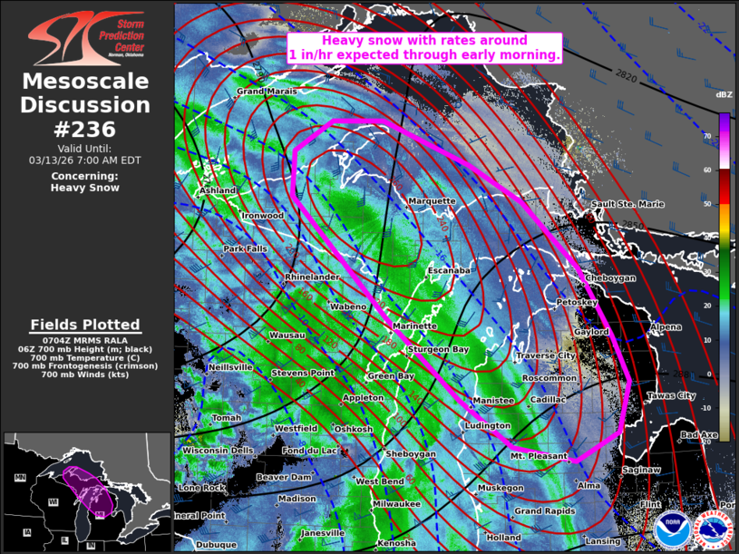
   Mesoscale Discussion 0236
   NWS Storm Prediction Center Norman OK
   0206 AM CDT Fri Mar 13 2026

   Areas affected...Parts of Upper MI...northern Lower MI...and far
   northeastern WI

   Concerning...Heavy snow

   Valid 130706Z - 131100Z

   SUMMARY...Heavy snow with rates around 1 inch per hour (locally
   higher) are expected through the early morning.

   DISCUSSION...Within the base of a compact shortwave trough moving
   eastward across MN, water-vapor imagery and VWP data indicate a
   robust jet streak (around 100 kt at 6 km per VWP data) impinging on
   WI. In response, a northwest/southeast-oriented frontogenetic zone
   is evolving slowly northeastward across WI, Upper MI, and northern
   Lower MI. Forcing for ascent is being maximized along/immediately
   north of this zone, where cold/deeply saturated profiles and the
   focused ascent are favoring a band of moderate to heavy snow. The
   strong/focused ascent within a deep/saturated DGZ will continue to
   favor heavy snowfall rates around 1 inch per hour, though locally
   higher rates to around 2 inches per hour are possible under the core
   of the band translating northeastward across Upper MI into northern
   Lower MI through the early morning hours.

   ..Weinman.. 03/13/2026

   ...Please see www.spc.noaa.gov for graphic product...

   ATTN...WFO...DTX...APX...GRR...MQT...GRB...

   LAT...LON   44318652 45258770 46658930 47168927 47518865 47538779
               47038636 46598548 45838455 45048402 44518375 43928393
               43598463 43778565 44318652
|
|
|
Top/All Mesoscale Discussions/Forecast Products/Home |
|
Source link