|
|
| Mesoscale Discussion 2309 | |
| < Previous MD | |

|
|
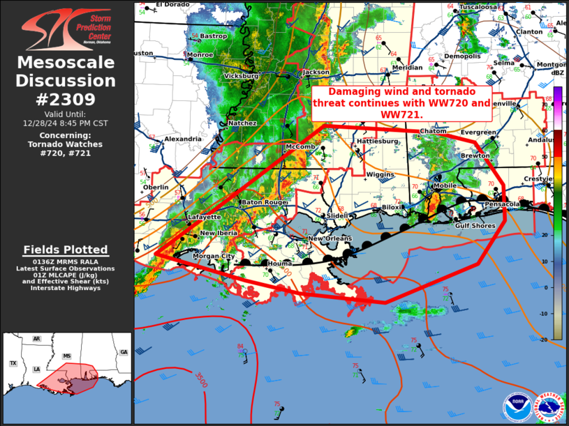
Mesoscale Discussion 2309 NWS Storm Prediction Center Norman OK 0739 PM CST Sat Dec 28 2024 Areas affected...southeastern Louisiana...southern Mississippi...and southern Alabama Concerning...Tornado Watch 720...721... Valid 290139Z - 290245Z The severe weather threat for Tornado Watch 720, 721 continues. SUMMARY...Threat for damaging winds and tornadoes continue within WW720 and WW721. DISCUSSION...A broken line of thunderstorms with embedded supercell structures continues to move eastward across southern Louisiana/Mississippi. Within the line, mesovortex structures continue to be observed on radar. Ahead of this line, semi-discrete cells continue to move northward and quickly merge with the line. Given this mixed mode, the threat for damaging wind and a tornado or two will continue for the next few hours. Ahead of this line near the marine front draped across southern Alabama, a supercell has moved inland and continues to exhibit mid-level rotation. This cell will eventually move northward into more stable air north of the marine boundary but may continue to pose risk for a tornado as it moves within mid to upper 60s dew point air with deep layer shear around 35-45 kts. ..Thornton/Gleason.. 12/29/2024 ...Please see www.spc.noaa.gov for graphic product... ATTN...WFO...MOB...JAN...LIX...LCH... LAT...LON 29769250 30439153 31618979 31518798 31358732 30758687 30248687 29648731 29128880 29259019 29429104 29769250 |
|
|
Top/All Mesoscale Discussions/Forecast Products/Home |
|


