|
|
| Mesoscale Discussion 2271 | |
| < Previous MD | |

|
|
   Mesoscale Discussion 2271
   NWS Storm Prediction Center Norman OK
   1117 PM CST Tue Dec 17 2024

   Areas affected...parts of northeastern
   Texas...southeastern...southwestern Arkansas

   Concerning...Severe potential...Watch unlikely

   Valid 180517Z - 180715Z

   Probability of Watch Issuance...5 percent

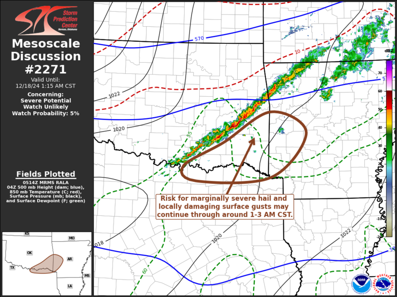
   SUMMARY...Thunderstorms posing a risk for marginally severe hail and
   wind may persist through around 1-3 AM CST, mainly across the Red
   River vicinity of northeast Texas through southeastern Oklahoma and
   portions of southwestern Arkansas.

   DISCUSSION...Thunderstorms have been slowly intensifying in a narrow
   band, generally focused along a pre-frontal confluence zone likely
   to continue an eastward progression before being overtaken by the
   southeastward advancing cold front later tonight.  This is being
   supported by destabilization associated with moistening within
   southerly return flow, largely above a residual cool and stable
   boundary layer.  Near the Red River into southeastern Oklahoma, it
   appears that this is becoming rooted close to the surface, aided by
   near-surface thermal and moisture advection.  And there may be a
   continuing window for the evolution of transient supercell
   structures posing a risk for marginally severe hail and wind gusts
   through around 07-09Z.

   ..Kerr/Smith.. 12/18/2024

   ...Please see www.spc.noaa.gov for graphic product...

   ATTN...WFO...LZK...SHV...TSA...FWD...OUN...

   LAT...LON   34479585 35259440 34709331 33589440 33479667 33859706
               34479585
|
|
|
Top/All Mesoscale Discussions/Forecast Products/Home |
|


