|
|
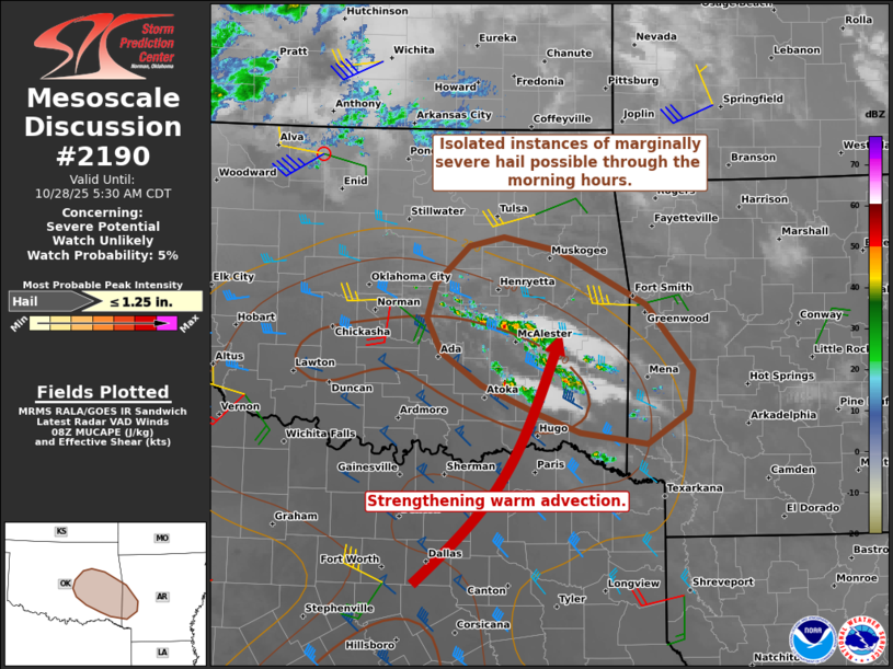
| Mesoscale Discussion 2190 | |

|
|
   Mesoscale Discussion 2190
   NWS Storm Prediction Center Norman OK
   0305 AM CDT Tue Oct 28 2025

   Areas affected...Portions of eastern Oklahoma into far western
   Arkansas

   Concerning...Severe potential...Watch unlikely

   Valid 280805Z - 281030Z

   Probability of Watch Issuance...5 percent

   SUMMARY...Isolated instances of marginally severe hail cannot be
   ruled out across portions of eastern Oklahoma into far western
   Arkansas through the morning hours.

   DISCUSSION...At the nose of a strengthening low-level jet (around
   35-40 kt per FWS VWP) and related warm-advection plume, isolated to
   widely scattered elevated thunderstorms are evolving across eastern
   OK early this morning. As moistening continues within the effective
   inflow layer for this activity (rooted at around 900 mb), MUCAPE
   should increase to upwards of 1500 J/kg. This elevated instability,
   coupled with 40-50 kt of effective shear, may promote
   isolated/embedded cellular structures with transient rotation
   through the morning hours. A couple instances of marginally severe
   hail (up to 1 inch) cannot be ruled out with any stronger updrafts
   that evolve.

   ..Weinman/Guyer.. 10/28/2025

   ...Please see www.spc.noaa.gov for graphic product...

   ATTN...WFO...LZK...SHV...TSA...OUN...

   LAT...LON   34639368 34239374 33929422 34039501 34229550 34509618
               34829666 35149683 35489674 35859634 35949592 35819528
               35299424 34639368

   MOST PROBABLE PEAK HAIL SIZE...UP TO 1.25 IN
|
|
|
Top/All Mesoscale Discussions/Forecast Products/Home |
|
Source link