| Mesoscale Discussion 216 | |
| < Previous MD | |

|
|
Mesoscale Discussion 0216
NWS Storm Prediction Center Norman OK
1140 AM CDT Wed Mar 11 2026
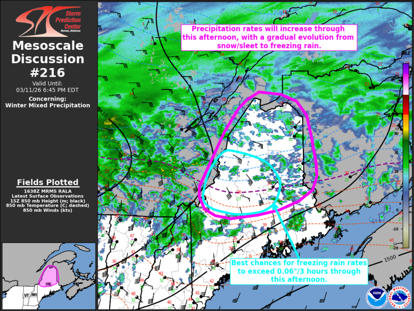
Areas affected...portions of central/northern Maine
Concerning...Winter mixed precipitation
Valid 111640Z - 112245Z
SUMMARY...Precipitation will expand across portions of
central/northern Maine through the afternoon/evening today with an
accompanying increase in rates ahead of an approaching upper-level
trough. Mixed precipitation is likely, with a gradual transition
from snow/sleet to freezing rain expected through this evening.
DISCUSSION...A surface cyclone is forecast to progress northeastward
from Lower Michigan into southeastern Canada today, with an
attendant warm front lifting northward across southern New England.
Increasing isentropic ascent to the north of this frontal boundary
coupled with favorable upper-level jet dynamics and a low-level
frontogenetic zone are expected to support an increase in
precipitation rates through this afternoon. Per the 12Z CAR
sounding, atmospheric profiles are below freezing across much of
northern Maine, but RAP forecast soundings indicate that a 850-700
mb warm nose is beginning to build across central Maine. With
surface temperatures ranging from the low-20s to low-30s F across
the region, this is supporting snow/sleet as the initial
precipitation types. With strong 850 mb warm air advection beginning
to spread northward, the warm nose will gradually build throughout
the afternoon, leading to a northward expansion of sleet and an
eventual transition to freezing rain for much of central/northern
Maine. The best chances for freezing rain rates to exceed 0.06
inches per 3 hours through the afternoon is expected to span from
the northern Kennebec Valley into the Central Highlands.
A further increase in winter precipitation rates is then anticipated
this evening into tonight as increasing DCVA downstream of an
upper-level shortwave trough overspreads the region amidst the
continuing strong, low-level warm air advection regime.
..Chalmers.. 03/11/2026
...Please see www.spc.noaa.gov for graphic product...
ATTN...WFO...CAR...GYX...
LAT...LON 47526844 47386796 47106766 46626752 46456748 46116741
45856739 45586753 45366792 45176849 45076909 45006989
45057034 45187066 45447082 45657081 46127051 46767011
47246968 47436943 47576909 47526844
|
|
|
Top/All Mesoscale Discussions/Forecast Products/Home |
|
Source link