| Mesoscale Discussion 212 | |
| < Previous MD | |

|
|
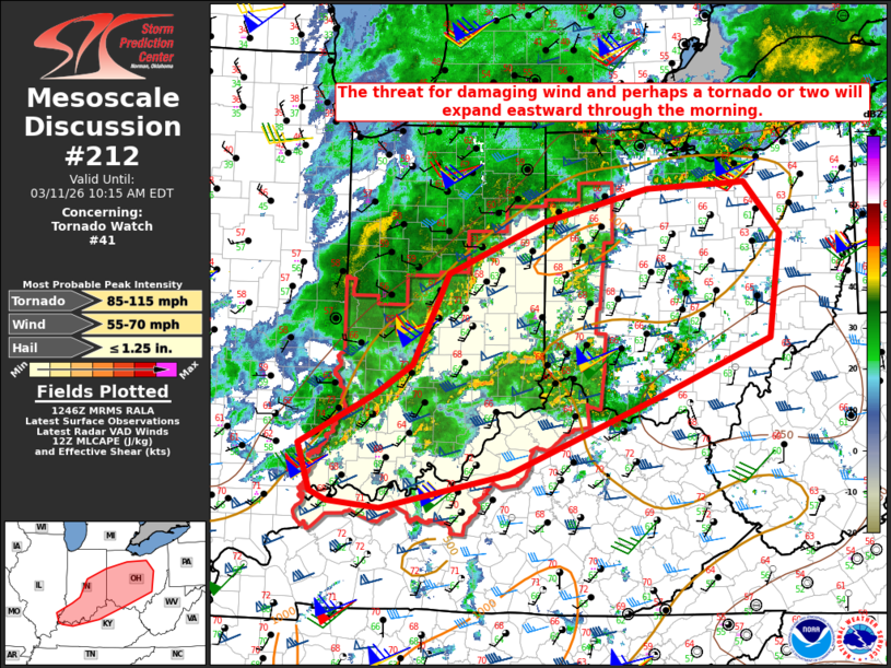
Mesoscale Discussion 0212 NWS Storm Prediction Center Norman OK 0749 AM CDT Wed Mar 11 2026 Areas affected...Parts of central/southern IN...OH...northern KY Concerning...Tornado Watch 41... Valid 111249Z - 111415Z The severe weather threat for Tornado Watch 41 continues. SUMMARY...The threat for damaging wind and perhaps a tornado or two will expand eastward through the morning. DISCUSSION...A loosely organized QLCS with a history of producing occasional severe gusts and wind damage is moving across parts of central/southern IN this morning. Very strong low-level flow (50-60 kt at 1 km AGL from the 12Z ILN sounding and regional VWPs) will continue to support wind-damage potential with this QLCS, despite the relatively shallow nature of the ongoing convection. Some additional enhancement to ascent and low-level flow associated with an MCV moving across southern IL may help to sustain a wind-damage threat through the morning, as convection spreads toward eastern IN and western OH. Low-level shear/SRH is also sufficient for some tornado threat, especially if any semi-discrete convection can mature along or ahead of the primary line. Local expansion of WW 41 and/or downstream watch issuance may eventually be needed, depending on short-term convective trends. In the wake of the morning convection, some recovery will be possible near the remnant outflow later this morning into the afternoon across parts of the Ohio Valley, which could result in another round of severe potential. ..Dean/Mosier.. 03/11/2026 ...Please see www.spc.noaa.gov for graphic product... ATTN...WFO...PBZ...RLX...CLE...ILN...LMK...IWX...IND...PAH... ILX... LAT...LON 40198611 40748483 41098338 41158205 40608156 39508172 38908324 38078529 37708701 37778773 37878795 38378812 38988717 39178702 40198611 MOST PROBABLE PEAK TORNADO INTENSITY...85-115 MPH MOST PROBABLE PEAK WIND GUST...55-70 MPH MOST PROBABLE PEAK HAIL SIZE...UP TO 1.25 IN |
|
|
Top/All Mesoscale Discussions/Forecast Products/Home |
|
Source link