| Mesoscale Discussion 197 | |
| < Previous MD Next MD > | |

|
|
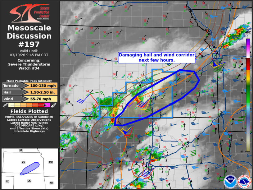
Mesoscale Discussion 0197 NWS Storm Prediction Center Norman OK 0739 PM CDT Tue Mar 10 2026 Areas affected...extreme northern Oklahoma across south-central into east-central Kansas Concerning...Severe Thunderstorm Watch 34... Valid 110039Z - 110245Z The severe weather threat for Severe Thunderstorm Watch 34 continues. SUMMARY...A corridor of damaging hail and wind potential is evident along the boundary into south-central and eastern Kansas. DISCUSSION...Cells continue to evolve out of northwest OK and now approaching the Wichita area. These storms are riding along the boundary/instability gradient, where shear and instability remain very favorable for damaging hail. Upstream over central OK, the 00Z OUN sounding showed 2500 J/kg MLCAPE along with strong mid to high level winds with elongated hodograph. Similar wind profiles exist into southern KS, and the low-level jet this evening will maintain a flow of instability into these storms. An eventual tornado risk may develop over southeast KS as well later this evening with any additional discrete development ahead of the existing bows. ..Jewell.. 03/11/2026 ...Please see www.spc.noaa.gov for graphic product... ATTN...WFO...TOP...ICT...OUN...DDC... LAT...LON 37649611 36999760 36739856 36739889 36989885 37169858 37459836 37779794 38579618 38529557 38239538 37989555 37649611 MOST PROBABLE PEAK TORNADO INTENSITY...100-130 MPH MOST PROBABLE PEAK WIND GUST...55-70 MPH MOST PROBABLE PEAK HAIL SIZE...1.50-2.50 IN |
|
|
Top/All Mesoscale Discussions/Forecast Products/Home |
|
Source link