| Mesoscale Discussion 187 | |
| < Previous MD | |
|
|
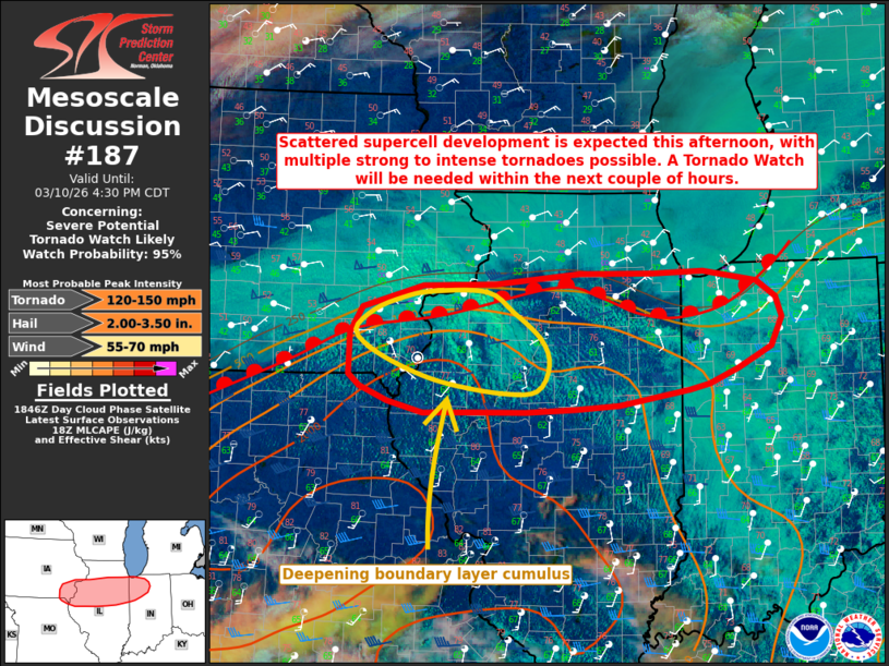
   Mesoscale Discussion 0187
   NWS Storm Prediction Center Norman OK
   0153 PM CDT Tue Mar 10 2026

   Areas affected...portions of southeastern Iowa/northeastern Missouri
   into northern Illinois and northwest Indiana

   Concerning...Severe potential...Tornado Watch likely

   Valid 101853Z - 102130Z

   Probability of Watch Issuance...95 percent

   SUMMARY...Supercell development along a surface warm front appears
   likely across portions of the Midwest this afternoon, with a threat
   for all severe hazards, including hail to 2+ inches in diameter and
   a risk for multiple strong to intense tornadoes (EF2-3+). While the
   timing of convective initiation remains somewhat uncertain, a
   Tornado Watch will be needed to cover this threat within the next
   1-2 hours.

   DISCUSSION...Latest GOES visible satellite imagery depicts deepening
   cumulus across portions of northeastern Missouri into southwestern
   Iowa and western Illinois. Recent observations also show an
   increasingly unstable low-level air mass characterized by low-to-mid
   60s F surface dewpoints south of a warm frontal boundary. While
   synoptic-scale forcing is expected to remain modest at best,
   continued low-level moist advection coupled with diurnal heating and
   strong mid-to-upper level flow across the Midwest are expected to
   support scattered severe thunderstorm development this afternoon.

   Moderate to strong instability (1500-2500 J/kg MLCAPE), steep
   mid-level lapse rates of 7-8 C/km, and strong effective bulk shear
   50+ kts will support a very favorable environment for intense
   supercells capable of all severe hazards. Very large hail of 2+
   inches in diameter will be possible initially. While low-level shear
   is currently modest per the ILX 18Z special sounding and VWP, a
   strengthening south-southwesterly low-level jet will favor an
   accompanying strong increase in low-level shear and effective SRH
   through this evening. The resultant enlarged/curved low-level
   hodographs will support intense low-level mesocyclones with
   supercells and an increasing risk for tornadoes (some within the
   EF2-3+ range) along and immediately south of the surface warm front.
   While low-level stability is expected to limit tornado potential
   north of this boundary, elevated supercells that develop/persist on
   the cool side of the warm front will continue to pose a threat for
   large to very large hail. The timing of convective initiation
   remains a bit uncertain, but a Tornado Watch will be needed within
   the next 1-2 hours to cover these threats.

   ..Chalmers/Gleason.. 03/10/2026

   ...Please see www.spc.noaa.gov for graphic product...

   ATTN...WFO...IWX...IND...LOT...ILX...DVN...

   LAT...LON   41039205 41309188 41529106 41559007 41658890 41658791
               41688721 41568648 41408623 41198615 40888630 40678675
               40518715 40448741 40288838 40248898 40228965 40219039
               40209104 40329153 40479192 40599207 41039205

   MOST PROBABLE PEAK TORNADO INTENSITY...120-150 MPH
   MOST PROBABLE PEAK WIND GUST...55-70 MPH
   MOST PROBABLE PEAK HAIL SIZE...2.00-3.50 IN
|
|
|
Top/All Mesoscale Discussions/Forecast Products/Home |
|
Source link