| Mesoscale Discussion 186 | |
| < Previous MD | |

|
|
   Mesoscale Discussion 0186
   NWS Storm Prediction Center Norman OK
   0135 PM CDT Tue Mar 10 2026

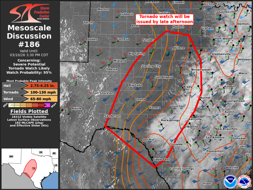
   Areas affected...Edwards Plateau to the Big Country in west TX

   Concerning...Severe potential...Tornado Watch likely

   Valid 101835Z - 102030Z

   Probability of Watch Issuance...95 percent

   SUMMARY...Severe storms are expected to initiate across the western
   Edwards Plateau and Concho Valley. Very large to giant hail along
   with an increasing tornado threat is expected into early evening,
   especially across the Edwards Plateau vicinity. A tornado watch will
   be issued by 21Z.

   DISCUSSION...High-based cumulus development is ongoing across the
   Permian Basin and Trans-Pecos, along the leading edge of stronger
   large-scale ascent downstream of the northwest Mexico shortwave
   trough. The warm-moist sector ahead of the west TX dryline continues
   to destabilize, with moderate buoyancy prevalent towards central TX.
   18Z FWD sounding sampled a pronounced EML with substantial MLCIN,
   likely limiting initial severe potential to west of the residual
   stratocumulus deck lingering over central TX.

   Storm development should emanate out of the high-based cumulus
   across the western Edwards Plateau and Concho Valley. With robust
   southwesterly speed shear in the mid to upper levels, atop low-level
   southerlies, wind profiles will be conducive to supercells and
   eventual upscale growth into bowing linear segments. The latter
   should be favored with northern/northeast extent, with some
   uncertainty on just how far north sustained supercell development
   will occur into the TX Big Country.

   The very large hail to giant hail threat, along with an increasing
   tornado risk should tend to be centered on the Edwards Plateau where
   larger buoyancy and more discrete supercell structures impinge on an
   increasing low-level jet by early evening. This setup may yield a
   couple long-track/intense supercells.

   ..Grams/Gleason.. 03/10/2026

   ...Please see www.spc.noaa.gov for graphic product...

   ATTN...WFO...FWD...EWX...SJT...LUB...MAF...

   LAT...LON   29870232 31380170 31400164 32000123 32590064 33079997
               32949907 32099859 31019859 30389888 29519955 28819996
               28520041 29870232

   MOST PROBABLE PEAK TORNADO INTENSITY...100-130 MPH
   MOST PROBABLE PEAK WIND GUST...65-80 MPH
   MOST PROBABLE PEAK HAIL SIZE...2.75-4.25 IN
|
|
|
Top/All Mesoscale Discussions/Forecast Products/Home |
|
Source link


