| Mesoscale Discussion 174 | |
| < Previous MD | |
|
|
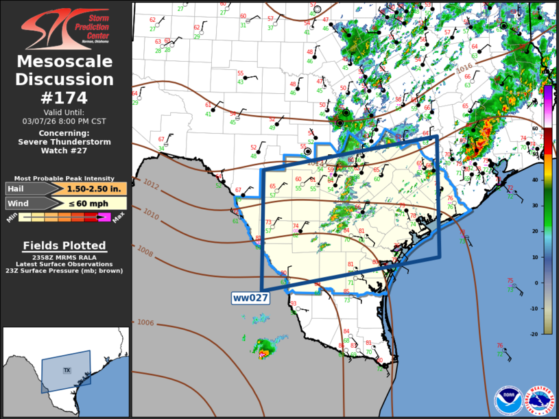
Mesoscale Discussion 0174 NWS Storm Prediction Center Norman OK 0601 PM CST Sat Mar 07 2026 Areas affected...South Central Texas Concerning...Severe Thunderstorm Watch 27... Valid 080001Z - 080200Z The severe weather threat for Severe Thunderstorm Watch 27 continues. SUMMARY...Scattered strong to locally severe convection will continue across south central Texas. DISCUSSION...Surface front continues advancing steadily south across south central TX early this evening. While surface temperatures have warmed considerably along the lower Rio Grande Valley, very little convection is noted across the warm sector. Latest radar data depicts scattered robust elevated convection north of the wind shift, and this activity is gradually developing south as the front advances toward deep south TX. Given the weak height rises noted across this region, frontal ascent should continue to be the primary mechanism for thunderstorm development. Forecast soundings suggest parcel lift may be near 1km, and adequate MUCAPE exists north of the wind shift for a continued hail risk with the most robust updrafts. ..Darrow.. 03/08/2026 ...Please see www.spc.noaa.gov for graphic product... ATTN...WFO...HGX...CRP...EWX... LAT...LON 29600003 30269621 27939622 27290003 29600003 MOST PROBABLE PEAK WIND GUST...UP TO 60 MPH MOST PROBABLE PEAK HAIL SIZE...1.50-2.50 IN |
|
|
Top/All Mesoscale Discussions/Forecast Products/Home |
|
Source link