| Mesoscale Discussion 170 | |
| < Previous MD Next MD > | |

|
|
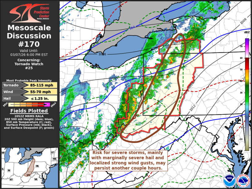
Mesoscale Discussion 0170 NWS Storm Prediction Center Norman OK 0255 PM CST Sat Mar 07 2026 Areas affected...parts of northern West Virginia...western Pennsylvania...southwestern New York Concerning...Tornado Watch 25... Valid 072055Z - 072300Z The severe weather threat for Tornado Watch 25 continues. SUMMARY...The risk for, mainly, marginally severe hail and locally damaging wind gusts may persist another couple of hours, but this potential appears unlikely to develop eastward across New York State, or to the east/southeast of the Allegheny Mountains. DISCUSSION...Surface observations have indicated further downward mixing of surface dew points with continuing daytime heating ahead of convection spreading into the Allegheny Plateau, with surface winds remaining westerly to southwesterly across surface troughing into the higher terrain. While low-level hodographs may be conditionally supportive of tornadic potential near the trough, it is not clear that thermodynamic profiles are supportive. Eastward, and particularly to the east/southeast of the crest of the Allegheny Mountains, cool to cold and stable boundary-layer air is either being maintained or slow to erode. As stronger storms cross the higher terrain into and through early evening, they should tend to weaken with diminishing risk of producing severe hail and damaging surface gusts. ..Kerr.. 03/07/2026 ...Please see www.spc.noaa.gov for graphic product... ATTN...WFO...BUF...CTP...LWX...PBZ...RLX...CLE... LAT...LON 42577894 42257844 41197882 40587876 40017903 39557942 39167980 38748078 38988157 39928074 42577894 MOST PROBABLE PEAK TORNADO INTENSITY...85-115 MPH MOST PROBABLE PEAK WIND GUST...55-70 MPH MOST PROBABLE PEAK HAIL SIZE...UP TO 1.25 IN |
|
|
Top/All Mesoscale Discussions/Forecast Products/Home |
|
Source link