| Mesoscale Discussion 167 | |
| < Previous MD | |

|
|
Mesoscale Discussion 0167
NWS Storm Prediction Center Norman OK
1157 AM CST Sat Mar 07 2026
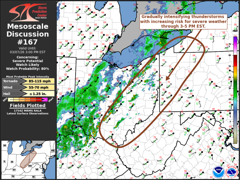
Areas affected...eastern Ohio...northwestern West Virginia...western
Pennsylvania...southwestern New York
Concerning...Severe potential...Watch likely
Valid 071757Z - 072000Z
Probability of Watch Issuance...80 percent
SUMMARY...Intensifying thunderstorm development may become capable
of producing marginally severe hail, increasing risk for damaging
wind gusts and perhaps accompanied by potential for a couple of
tornadoes by 3-5 PM EST.
DISCUSSION...Boundary-layer layer moisture return across the upper
Ohio Valley into lower Great Lakes region is ongoing, but remains
somewhat modest with surface dew points increasing through the
mid/upper 50s. However warming and mixing with continuing
insolation is contributing to steepening low-level lapse rates and
thermodynamic profiles with weak to modest CAPE increasing in excess
of 500 J/kg, beneath southwesterly deep-layer mean ambient flow
increasing to near 50 kt.
Deepening convective development now appears underway along and
discretely ahead of a convectively generated pre-cold frontal
surface boundary now advancing across central into eastern Ohio. As
this continues into the Allegheny Plateau through 21-22Z, developing
thunderstorm activity appears likely to intensify and organize.
This may include a few evolving supercell structures within and
ahead of an evolving line, accompanied by a risk for severe hail and
damaging wind gusts.
With surface winds generally veered to a fairly prominent westerly
component, the degree to which low-level hodographs will become
supportive of tornadic potential remains unclear, particularly given
the still sizable boundary-layer temperature/dew point spreads.
However, as 850 mb winds strengthen to 50+ kt across eastern Ohio
into western Pennsylvania, various model derived output suggests
that profiles could become locally conducive to a supercell tornado
threat by late afternoon.
..Kerr/Guyer.. 03/07/2026
...Please see www.spc.noaa.gov for graphic product...
ATTN...WFO...BUF...CTP...PBZ...RLX...CLE...ILN...
LAT...LON 42537973 42127817 40797932 40018008 38738163 38358266
39088350 40548232 42537973
MOST PROBABLE PEAK TORNADO INTENSITY...85-115 MPH
MOST PROBABLE PEAK WIND GUST...55-70 MPH
MOST PROBABLE PEAK HAIL SIZE...UP TO 1.25 IN
|
|
|
Top/All Mesoscale Discussions/Forecast Products/Home |
|
Source link