| Mesoscale Discussion 160 | |
| < Previous MD | |
|
|
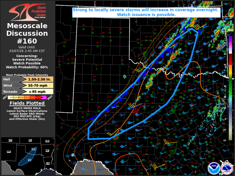
   Mesoscale Discussion 0160
   NWS Storm Prediction Center Norman OK
   1244 AM CST Sat Mar 07 2026

   Areas affected...Parts of southwest into north TX...central OK

   Concerning...Severe potential...Watch possible

   Valid 070644Z - 070845Z

   Probability of Watch Issuance...60 percent

   SUMMARY...Strong to locally severe storms will increase in coverage
   overnight. Watch issuance is possible.

   DISCUSSION...Storms are gradually increasing in coverage and
   intensity from northwest TX into south-central OK, along a weak cold
   front/surface trough. A sharper cold front is moving southeastward
   across the region, with convection ongoing from central into
   northeast OK along and immediately behind this front. The stronger
   front will eventually overtake the weaker boundary overnight, with a
   continued increase in storm development along and behind this front.
   Moderate MUCAPE and sufficient deep-layer flow/shear will support
   potential for organized storms, though convective mode may become
   complex due to the eventual undercutting nature of the cold front.

   Initial semi-discrete storms could pose a threat of large hail,
   given the favorable buoyancy and generally steep midlevel lapse
   rates. As loosely organized upscale growth occurs, some increase in
   severe-gust potential will be possible, especially with any bowing
   segments that remain rooted near the surface. A tornado also cannot
   be ruled out with any sustained cells immediately ahead of the
   primary front, given the presence of sufficiently enlarged low-level
   hodographs. While some uncertainty remains regarding the coverage
   and magnitude of the overnight severe threat, watch issuance is
   possible due to the potential for an increasing coverage of storms
   within a favorable environment.

   ..Dean/Gleason.. 03/07/2026

   ...Please see www.spc.noaa.gov for graphic product...

   ATTN...WFO...TSA...FWD...OUN...SJT...LUB...MAF...

   LAT...LON   32949750 32499792 31709918 30860096 30800214 31300216
               32010154 33499966 34089911 34839821 35519735 35989642
               35789608 35359622 34469656 33619711 32949750

   MOST PROBABLE PEAK TORNADO INTENSITY...UP TO 95 MPH
   MOST PROBABLE PEAK WIND GUST...55-70 MPH
   MOST PROBABLE PEAK HAIL SIZE...1.50-2.50 IN
|
|
|
Top/All Mesoscale Discussions/Forecast Products/Home |
|
Source link