| Mesoscale Discussion 159 | |
| < Previous MD | |

|
|
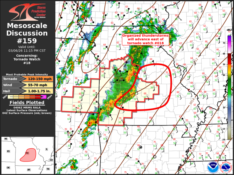
Mesoscale Discussion 0159 NWS Storm Prediction Center Norman OK 1008 PM CST Fri Mar 06 2026 Areas affected...Portions of central and eastern Missouri Concerning...Tornado Watch 18... Valid 070408Z - 070515Z The severe weather threat for Tornado Watch 18 continues. SUMMARY...Organized thunderstorms will spread east of Tornado Watch 018 in the next 1-2 hours. New severe thunderstorm watch is being considered downstream. DISCUSSION...Elongated band of convection has gradually organized over the last few hours, currently extending from northeast OK into central MO. While a few supercells are noted, especially over northeast OK, some bowing of the squall line is occurring over Camden/Laclede County. This portion of the line is beginning to surge a bit and damaging winds may become more common as this activity spreads into east-central MO. New severe thunderstorm watch is being considered to account for this evolution. ..Darrow.. 03/07/2026 ...Please see www.spc.noaa.gov for graphic product... ATTN...WFO...LSX...SGF... LAT...LON 38069290 38919236 38849099 37399113 37129284 37349377 38069290 MOST PROBABLE PEAK TORNADO INTENSITY...120-150 MPH MOST PROBABLE PEAK WIND GUST...55-70 MPH MOST PROBABLE PEAK HAIL SIZE...1.00-1.75 IN |
|
|
Top/All Mesoscale Discussions/Forecast Products/Home |
|
Source link