| Mesoscale Discussion 154 | |
| < Previous MD | |

|
|
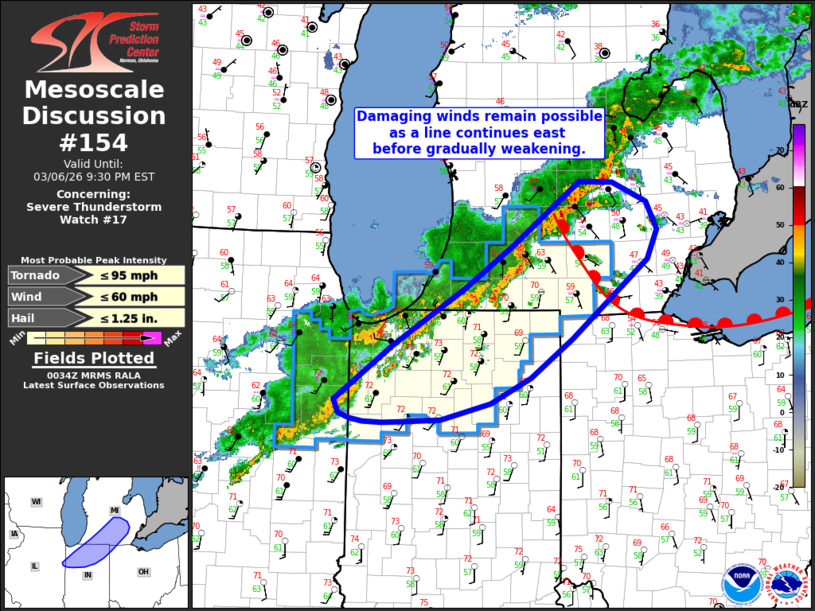
Mesoscale Discussion 0154 NWS Storm Prediction Center Norman OK 0637 PM CST Fri Mar 06 2026 Areas affected...Northern Indiana into southern Michigan Concerning...Severe Thunderstorm Watch 17... Valid 070037Z - 070230Z The severe weather threat for Severe Thunderstorm Watch 17 continues. SUMMARY...A squall line will continue east across northern Indiana and southern lower Michigan for the next couple of hours before gradually weakening. Damaging gusts remain the primary threat. DISCUSSION...Latest MRMS and GOES IR imagery continue to show new updraft development within a squall line draped from southern MI into northwest IN, and local radar imagery continues to show a few bowing segments within the line. Regional VWPs and latest RAP mesoanalysis continues to show a strongly sheared environment in place across the region with 0-3 km BWD values on the order of 30-40 knots and 40-50 knots winds within the lowest kilometer. This kinematic environment will continue to support the potential for organized/bowing segments within the line with an attendant threat for severe/damaging winds - especially with any meridionally-oriented segments. With time, a gradual weakening trend is expected as the squall line outpaces the axis of better surface-based buoyancy draped from western IL into northern IN. The onset of nocturnal cooling will further contribute to an overall reduction in convective intensity in the coming hours. ..Moore.. 03/07/2026 ...Please see www.spc.noaa.gov for graphic product... ATTN...WFO...DTX...IWX...GRR...IND...LOT... LAT...LON 40888772 41418696 41968605 42408539 43018453 42998411 42818366 42548353 42258366 41478464 41108518 40858569 40688634 40668681 40658709 40678735 40698751 40758766 40888772 MOST PROBABLE PEAK TORNADO INTENSITY...UP TO 95 MPH MOST PROBABLE PEAK WIND GUST...UP TO 60 MPH MOST PROBABLE PEAK HAIL SIZE...UP TO 1.25 IN |
|
|
Top/All Mesoscale Discussions/Forecast Products/Home |
|
Source link