| Mesoscale Discussion 149 | |
| < Previous MD | |
|
|
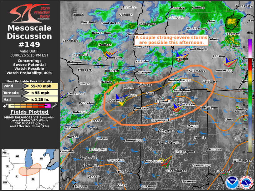
   Mesoscale Discussion 0149
   NWS Storm Prediction Center Norman OK
   0210 PM CST Fri Mar 06 2026

   Areas affected...southern Lower Michigan...northern Indiana...and
   northeast Illinois

   Concerning...Severe potential...Watch possible

   Valid 062010Z - 062215Z

   Probability of Watch Issuance...40 percent

   SUMMARY...A couple strong to severe storms are possible through the
   afternoon.

   DISCUSSION...An isolated thunderstorm has been gradually
   intensifying along a warm front in far southwestern Lower MI this
   afternoon, with additional deepening cumulus extending
   west-southwestward across northern IN into northeastern IL. Here,
   lower 60s dewpoints and diurnal heating has yielded a corridor of
   weak surface-based buoyancy along the southern edge of widespread
   clouds. Despite the weak buoyancy, strong deep-layer wind field
   (sampled by regional VWP) is yielding an elongated hodograph with
   enhanced low-level curvature. This environment may promote some
   storm organization this afternoon, including small clusters and
   brief/transient supercell structures. Locally damaging winds and
   perhaps a tornado risk will accompany the stronger storms that
   evolve. The overall severe risk may remain too isolated for a watch,
   though trends are being monitored.

   ..Weinman/Guyer.. 03/06/2026

   ...Please see www.spc.noaa.gov for graphic product...

   ATTN...WFO...IWX...GRR...LOT...

   LAT...LON   42008798 41978736 42018679 42298611 42508548 42508505
               42368463 41968443 41648459 41328490 41088542 40918596
               40738680 40658733 40658787 40678834 40898879 41138907
               41638905 41948858 42008798

   MOST PROBABLE PEAK TORNADO INTENSITY...UP TO 95 MPH
   MOST PROBABLE PEAK WIND GUST...55-70 MPH
   MOST PROBABLE PEAK HAIL SIZE...UP TO 1.25 IN
|
|
|
Top/All Mesoscale Discussions/Forecast Products/Home |
|
Source link