| Mesoscale Discussion 146 | |
| < Previous MD | |

|
|
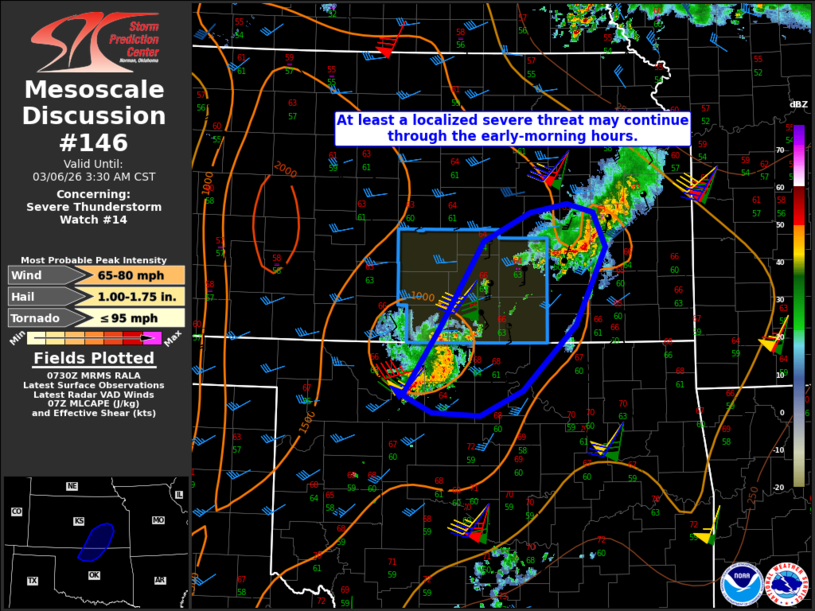
Mesoscale Discussion 0146 NWS Storm Prediction Center Norman OK 0131 AM CST Fri Mar 06 2026 Areas affected...Parts of northern OK into south-central/southeast KS Concerning...Severe Thunderstorm Watch 14... Valid 060731Z - 060930Z The severe weather threat for Severe Thunderstorm Watch 14 continues. SUMMARY...At least a localized severe threat may continue through the early morning hours. DISCUSSION...An earlier tornadic supercell has recently weakened east of Wichita, due to increasing CINH and decreasing low-level moisture quality with northeastward extent. Farther southwest, a small bowing segment has evolved from an earlier supercell cluster across north-central OK. The nocturnal increase in CINH should eventually lead to a weakening trend with this cluster as well, but given its current level of organization and very strong low-level flow noted on the KVNX and KICT VWPs, localized severe gusts and perhaps a brief tornado may accompany this cluster as it moves into south-central KS. Gusty to locally severe winds will also continue to be possible with this cluster even if it begins to decay. Otherwise, the environment remains conditionally favorable for supercells, but increasing low-level stability should tend to mitigate this threat with time. However, some threat for hail and/or a brief tornado cannot be ruled out if any additional supercells can evolve within the ongoing convection. ..Dean.. 03/06/2026 ...Please see www.spc.noaa.gov for graphic product... ATTN...WFO...TSA...TOP...ICT...OUN... LAT...LON 36459839 37149791 38059734 38349673 38439625 38349592 37989575 37189614 36499683 36249738 36269801 36459839 MOST PROBABLE PEAK TORNADO INTENSITY...UP TO 95 MPH MOST PROBABLE PEAK WIND GUST...65-80 MPH MOST PROBABLE PEAK HAIL SIZE...1.00-1.75 IN |
|
|
Top/All Mesoscale Discussions/Forecast Products/Home |
|
Source link