| Mesoscale Discussion 145 | |
| < Previous MD | |

|
|
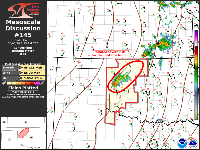
Mesoscale Discussion 0145 NWS Storm Prediction Center Norman OK 1142 PM CST Thu Mar 05 2026 Areas affected...Northwest Oklahoma Concerning...Tornado Watch 13... Valid 060542Z - 060715Z The severe weather threat for Tornado Watch 13 continues. SUMMARY...Severe threat will gradually decrease across northwest Oklahoma. Tornado watch will expire as scheduled. DISCUSSION...Small cluster of severe thunderstorms persists over northwest OK, primarily across Roger Mills into Dewey county. This activity is the remnants of a few eastern TX Panhandle supercells that appear to be primarily producing large hail as they spread downstream beneath a strong LLJ. It's not entirely clear how long this activity will continue to produce severe hail, but strong shear and adequate buoyancy favor at least robust updrafts, even as they gradually become elevated in nature. Given the expected decrease in intensity, new watch is not anticipated at this time. ..Darrow.. 03/06/2026 ...Please see www.spc.noaa.gov for graphic product... ATTN...WFO...OUN... LAT...LON 35799983 36749872 36859779 36249797 35439900 35409964 35799983 MOST PROBABLE PEAK TORNADO INTENSITY...85-115 MPH MOST PROBABLE PEAK WIND GUST...55-70 MPH MOST PROBABLE PEAK HAIL SIZE...1.00-1.75 IN |
|
|
Top/All Mesoscale Discussions/Forecast Products/Home |
|
Source link