| Mesoscale Discussion 142 | |
| < Previous MD | |

|
|
Mesoscale Discussion 0142
NWS Storm Prediction Center Norman OK
0832 PM CST Thu Mar 05 2026
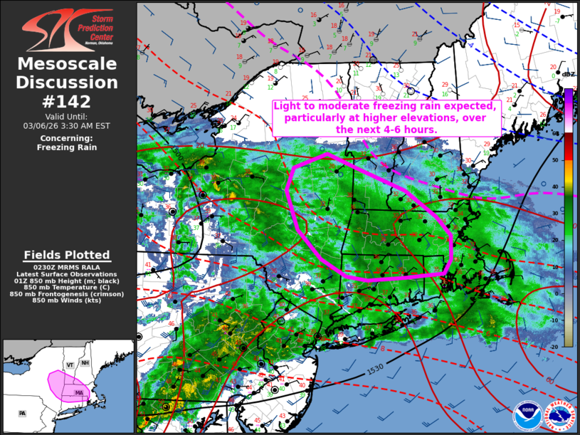
Areas affected...portions of eastern New York into southern New
England
Concerning...Freezing rain
Valid 060232Z - 060830Z
SUMMARY...Light to moderate freezing rain has begun across portions
of eastern New York into southern New England and is expected to
continue over the next 4-6 hours, especially for high elevations.
DISCUSSION...DCVA ahead of an approaching mid-level shortwave trough
will overspread portions of the Northeast over the next 4-6 hours.
Coupled with increasing 850 mb warm air advection, this is expected
to support an expansion of light to moderate freezing rain rates
already noted at some ASOS sites across portions of eastern New York
into southern New England. While regional surface temperatures are
hovering at or just above freezing in the low-to-mid 30s, modest
surface temperature decreases are expected over the next couple of
hours given weak surface cold air advection and evaporative cooling
amidst surface wet bulb temperatures near freezing. The greatest
potential for freezing rain rates to exceed 0.06"/3 hours is
expected across areas of higher terrain, particularly across the
eastern Catskill Mountains, Berkshires, Litchfield Hills, and
Worcester Hills. Rates are generally expected to remain lighter
within the intermediate Valleys owing to marginally warmer surface
temperatures, but heavier rates may be supported should stronger
surface CAA infiltrate these areas of lower terrain. Cooler
low-to-mid level temperatures are expected to support snow as the
primary precipitation type for areas farther north.
..Chalmers/Moore.. 03/06/2026
...Please see www.spc.noaa.gov for graphic product...
ATTN...WFO...GYX...BOX...BTV...OKX...ALY...
LAT...LON 41737137 41677218 41637295 41707339 41967393 42417441
43037466 43377452 43597381 43387319 43027216 42627152
42337121 41967122 41737137
|
|
|
Top/All Mesoscale Discussions/Forecast Products/Home |
|
Source link