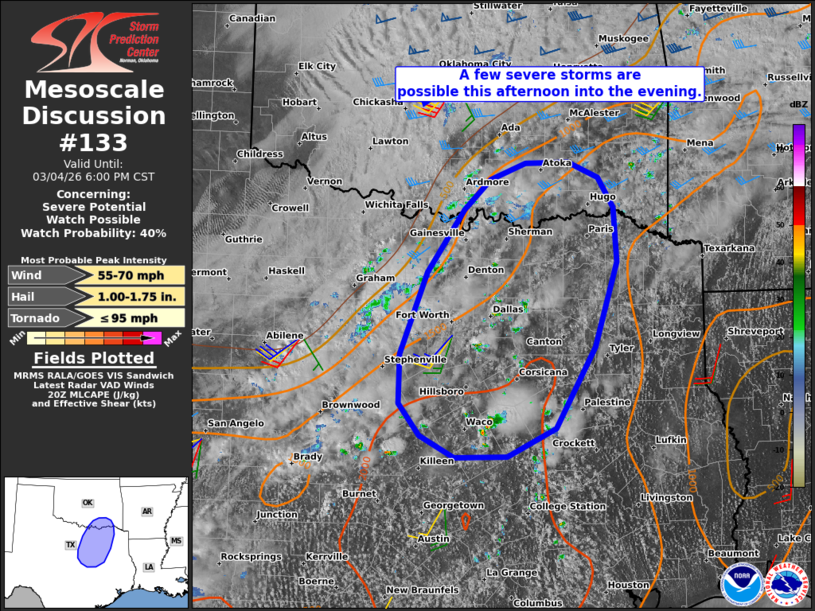
| Mesoscale Discussion 133 | |
| < Previous MD | |

|
|
   Mesoscale Discussion 0133
   NWS Storm Prediction Center Norman OK
   0301 PM CST Wed Mar 04 2026

   Areas affected...Parts of north/northeast Texas into southeastern
   Oklahoma

   Concerning...Severe potential...Watch possible

   Valid 042101Z - 050000Z

   Probability of Watch Issuance...40 percent

   SUMMARY...A few severe storms are possible this afternoon into the
   evening, with the primary concerns being damaging gusts and severe
   hail. A watch may eventually be needed.

   DISCUSSION...The latest visible satellite imagery shows continued
   diurnal heating/destabilization of a relatively moist air mass
   (middle/upper 60s dewpoints) extending from parts of north/northeast
   TX toward the Red River. Despite weak large-scale forcing for
   ascent, continued erosion of inhibition at the base of the EML (see
   latest DAL ACARS soundings) is promoting isolated convective
   initiation within zones of differential heating and low-level
   confluence. Current thinking is that this trend will continue
   through the afternoon, with mainly isolated storm coverage. While
   modest deep-layer shear (25-30-kt midlevel flow per FWS VWP) and the
   weak large-scale ascent may limit storm organization in the
   near-term, the destabilizing boundary layer and steep midlevel lapse
   rates may still promote locally damaging gusts and sporadic severe
   hail on an isolated basis this afternoon.

   With time, a strengthening southerly low-level jet should favor
   additional storm development and organization later this afternoon
   into the evening, when the risk of damaging winds and severe hail
   should increase. A watch may eventually be needed for parts of the
   area, though timing is uncertain.

   ..Weinman/Guyer.. 03/04/2026

   ...Please see www.spc.noaa.gov for graphic product...

   ATTN...WFO...SHV...TSA...FWD...OUN...

   LAT...LON   32359798 33259762 33959714 34289680 34469634 34479578
               34309540 33969519 33369515 32439545 31559595 31239658
               31239726 31469771 31829799 32359798

   MOST PROBABLE PEAK TORNADO INTENSITY...UP TO 95 MPH
   MOST PROBABLE PEAK WIND GUST...55-70 MPH
   MOST PROBABLE PEAK HAIL SIZE...1.00-1.75 IN
|
|
|
Top/All Mesoscale Discussions/Forecast Products/Home |
|
Source link


