| Mesoscale Discussion 130 | |
| < Previous MD | |

|
|
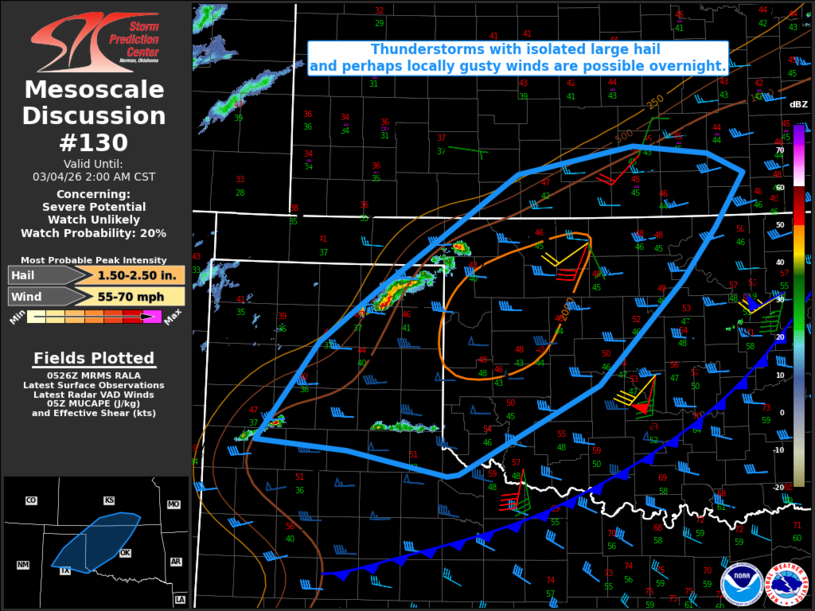
   Mesoscale Discussion 0130
   NWS Storm Prediction Center Norman OK
   1127 PM CST Tue Mar 03 2026

   Areas affected...Parts of the TX/OK Panhandles...western into
   north-central OK...south-central KS

   Concerning...Severe potential...Watch unlikely

   Valid 040527Z - 040800Z

   Probability of Watch Issuance...20 percent

   SUMMARY...Thunderstorms with isolated large hail and perhaps locally
   gusty winds are possible overnight.

   DISCUSSION...Elevated convection has recently developed across parts
   of the TX Panhandle, with increasing midlevel cumulus noted into far
   northwest OK. A further increase in elevated convection is expected
   with time overnight, as a mid/upper-level shortwave trough currently
   over the central/southern Rockies begins to impinge upon a reservoir
   of moderate elevated buoyancy (with MUCAPE of 1000-2000 J/kg).

   Steep midlevel lapse rates (as noted in regional 00Z soundings) and
   strong mid/upper-level flow (with effective shear of near/above 40
   kt) are favorable for organized elevated storms with large hail,
   potentially into the 1.5 - 2 inch diameter range. However, recent
   CAM guidance generally depicts a transition to a cluster or linear
   mode with time, which could temper the magnitude and coverage of the
   hail threat to some extent. Also, despite a substantial cool/stable
   near-surface layer to the north of an advancing cold front, locally
   gusty surface winds cannot be ruled out if any substantial
   clustering or upscale growth occurs.

   ..Dean/Mosier.. 03/04/2026

   ...Please see www.spc.noaa.gov for graphic product...

   ATTN...WFO...TSA...ICT...OUN...DDC...LUB...AMA...

   LAT...LON   34269994 34520122 34620239 35670160 36210088 37469902
               37749750 37659652 37449606 36889643 36329688 35229797
               34289978 34269994

   MOST PROBABLE PEAK WIND GUST...55-70 MPH
   MOST PROBABLE PEAK HAIL SIZE...1.50-2.50 IN
|
|
|
Top/All Mesoscale Discussions/Forecast Products/Home |
|
Source link