| Mesoscale Discussion 129 | |
| < Previous MD | |

|
|
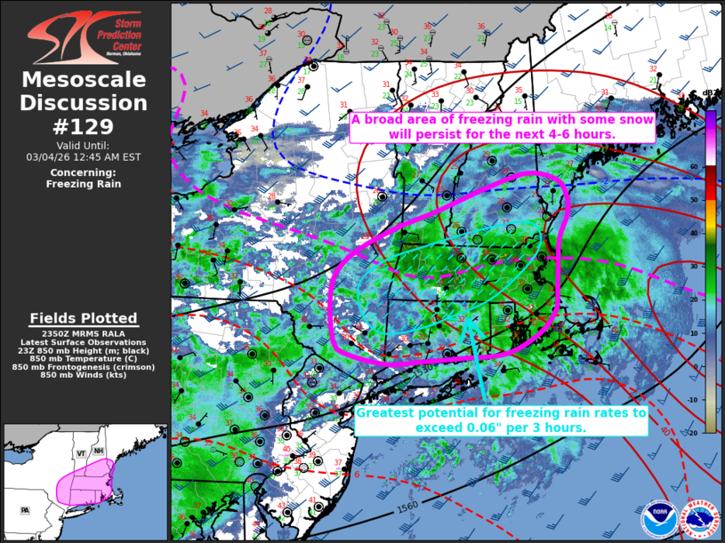
   Mesoscale Discussion 0129
   NWS Storm Prediction Center Norman OK
   0552 PM CST Tue Mar 03 2026

   Areas affected...portions of eastern New York into southern and
   central New England

   Concerning...Freezing rain

   Valid 032352Z - 040545Z

   SUMMARY...An area of freezing rain, with some snow on the northern
   edge, will continue for the next 4-6 hours.

   DISCUSSION...A broad precipitation shield is ongoing across portions
   of eastern New York into southern and central New England this
   afternoon amidst broad isentropic ascent within the 925-700 mb
   layer. Area VWPs have sampled increasing 1-3 km AGL flow over the
   past few hours to 40-50 knots. Aided by ascent within the right
   entrance region of an upper-level jet streak, this is supporting
   ongoing freezing rain, with rates occasionally exceeding 0.06" per 3
   hours. Forecast soundings indicate the 850 mb warm nose will expand
   farther north this evening amidst the low-level warm air advection
   regime. With surface temperatures forecast to remain below freezing
   (upper 20s to lower 30s), expectation is for freezing rain to
   persist for the next 4-6 hours with a gradual northward expansion.
   The greatest potential for heavier rates is anticipated along a
   corridor from far eastern New York across western Massachusetts and
   into far southern New Hampshire where the strongest ascent is
   forecast to overlap favorable thermodynamic profiles to support the
   heaviest precipitation rates. Farther to the north, maximum column
   temperatures are likely to remain below freezing and are expected to
   support snow as the primary precipitation type. Veering low-level
   winds and drier mid-level air will then accompany a cold frontal
   passage later tonight, bringing an end to precipitation by 8-10 UTC
   (3-5 AM EST).

   ..Chalmers/Lyons.. 03/03/2026

   ...Please see www.spc.noaa.gov for graphic product...

   ATTN...WFO...GYX...BOX...BTV...OKX...ALY...BGM...

   LAT...LON   41897071 41637094 41387151 41317225 41277299 41237350
               41357412 41527440 42177445 42557418 42907344 43167266
               43417190 43617116 43547064 43347049 43127046 42807061
               42427065 42007066 41897071
|
|
|
Top/All Mesoscale Discussions/Forecast Products/Home |
|
Source link