| Mesoscale Discussion 128 | |
| < Previous MD | |

|
|
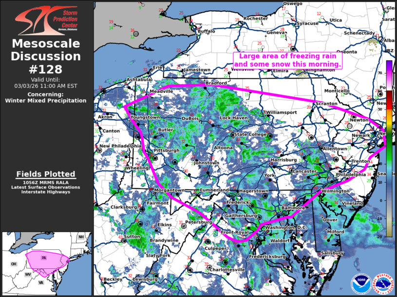
   Mesoscale Discussion 0128
   NWS Storm Prediction Center Norman OK
   0458 AM CST Tue Mar 03 2026

   Areas affected...parts of the Mid-Atlantic into the New York Metro
   Area.

   Concerning...Winter mixed precipitation

   Valid 031058Z - 031600Z

   SUMMARY...An area of freezing rain, with some snow on the northern
   extent, continues this morning.

   DISCUSSION...A precipitation shield is expanding across the
   Mid-Atlantic this morning as isentropic ascent increases. Area VWPs
   at LWX, CCX, and PBZ have sampled increasing 1-2 km flow over the
   past few hours to near 35 to 40 knots. Even stronger flow (~45
   knots) is evident on the RLX VWP. This stronger flow will spread
   northeastward through the morning and will result in greater
   precipitation rates. Mostly freezing rain, with some snow is being
   observed this morning across the region. Across northern Virginia
   and Maryland, where temperatures are currently near 32F, expect a
   transition to mostly rain relatively soon as southerly flow
   strengthens this morning. Farther north across Pennsylvania, expect
   the freezing rain to persist into the morning where wet-bulb
   temperatures are in the 20s. Across eastern Pennsylvania into
   northern New Jersey and southern New York, temperatures will stay
   well below freezing through the morning. Forecast soundings indicate
   precipitation may be primarily snow initially with a few hour
   transition to freezing rain by late morning.

   ..Bentley.. 03/03/2026

   ...Please see www.spc.noaa.gov for graphic product...

   ATTN...WFO...OKX...PHI...BGM...CTP...LWX...PBZ...CLE...

   LAT...LON   39677555 39167633 39167644 39127666 39017712 38907720
               38707751 38677767 38697782 38767800 38967828 39267873
               39567946 39837982 40348011 40478023 40768029 40878034
               41048051 41218065 41388078 41827962 41867842 41487544
               41147424 40897383 40577379 40357420 40117437 39887481
               39677555
|
|
|
Top/All Mesoscale Discussions/Forecast Products/Home |
|
Source link