| Mesoscale Discussion 125 | |
| < Previous MD | |

|
|
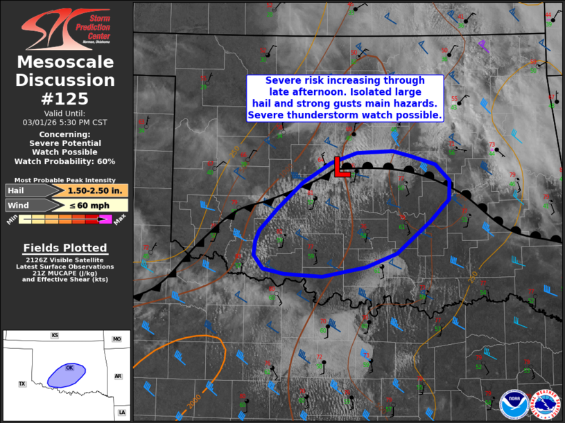
   Mesoscale Discussion 0125
   NWS Storm Prediction Center Norman OK
   0331 PM CST Sun Mar 01 2026

   Areas affected...portions of central and south-central Oklahoma

   Concerning...Severe potential...Watch possible

   Valid 012131Z - 012330Z

   Probability of Watch Issuance...60 percent

   SUMMARY...Isolated severe risk will increase through late
   afternoon/evening. A couple of storms could produce large hail and
   gusty winds across central/south-central Oklahoma in the 5 PM - 10
   PM time period.

   DISCUSSION...A cumulus field has been expanding across the central
   OK vicinity the past couple of hours. Warm, moist advection in the
   low and midlevels has allowed surface dewpoints to increase into the
   57-60 F range between the I-44 and I-35 corridors south of the OKC
   Metro, with more modest boundary layer moisture noted with northeast
   extent. Substantial midlevel moistening between the 850-700 mb layer
   was noted between 1730z-1830z in midday ACARS/TAMDAR data from OKC.
   Furthermore, a 21z sounding from OUN showed only weak capping with
   MUCAPE approaching 1500 J/kg amid midlevel lapse rates near 7.5
   C/km.

   As modest large-scale ascent overspreads the region, isolated to
   widely scattered thunderstorms are expected to develop in the 22-00z
   time frame near a surface low and cold front oriented from the OKC
   area southwestward along the I-44 corridor. The strongest storms may
   produce large hail in the 1.5-2.0 inch range, and gusty winds of
   45-60 mph. It remains uncertain how many storms may develop, and the
   corridor for severe-caliber hail may remain fairly narrow in space
   and time. Trends will continue to be monitored for possible watch
   issuance in the next couple of hours.

   ..Leitman/Smith.. 03/01/2026

   ...Please see www.spc.noaa.gov for graphic product...

   ATTN...WFO...TSA...OUN...

   LAT...LON   35089605 34829632 34459680 34299723 34179786 34219840
               34269869 34439882 34599881 34729874 34979849 35279813
               35509773 35629736 35649686 35599659 35489625 35309604
               35089605

   MOST PROBABLE PEAK WIND GUST...UP TO 60 MPH
   MOST PROBABLE PEAK HAIL SIZE...1.50-2.50 IN
|
|
|
Top/All Mesoscale Discussions/Forecast Products/Home |
|
Source link