| Mesoscale Discussion 124 | |
| < Previous MD | |

|
|
Mesoscale Discussion 0124
NWS Storm Prediction Center Norman OK
1139 AM CST Sun Mar 01 2026
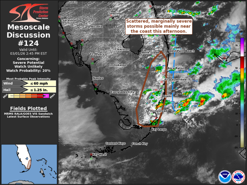
Areas affected...South Florida
Concerning...Severe potential...Watch unlikely
Valid 011739Z - 011945Z
Probability of Watch Issuance...20 percent
SUMMARY...Scattered storms are possible primarily near and along the
South Florida coast this afternoon. Isolated damaging winds and
marginally severe hail are the expected hazards. A watch is not
expected.
DISCUSSION...Convection continues to increase near the South Florida
coast this afternoon as temperature are reaching the upper 70s to
low 80s F. Localized convergence along with modest mid-level ascent
appears to be the largest contributors to this activity. With time,
a more well-developed sea breeze will likely move inland and promote
additional development. Around 1500 J/kg MLCAPE and 30-35 kts of
effective shear will allow a few storms to organize and potentially
produce isolated damaging winds and marginally severe hail.
Convection over the Gulf Stream has produce outflow that is
approaching the eastern Peninsula coast. This could impact the
duration of the most intense activity, though a brief uptick in wind
gust potential is also possible as this boundary interacts with
ongoing storms.
..Wendt/Smith.. 03/01/2026
...Please see www.spc.noaa.gov for graphic product...
ATTN...WFO...MFL...KEY...
LAT...LON 25208029 25198059 25238072 25538078 26528043 26748020
26608009 25818010 25208029
MOST PROBABLE PEAK WIND GUST...UP TO 60 MPH
MOST PROBABLE PEAK HAIL SIZE...UP TO 1.25 IN
|
|
|
Top/All Mesoscale Discussions/Forecast Products/Home |
|
Source link