There’s not much new to report on the two Atlantic tropical disturbances we’ve been tracking this week in the Atlantic – 96L off the coast of North Carolina and 95L in the central tropical Atlantic. Both are still expected to become tropical depressions or tropical storms in the next two days, but are not in a hurry to do so.
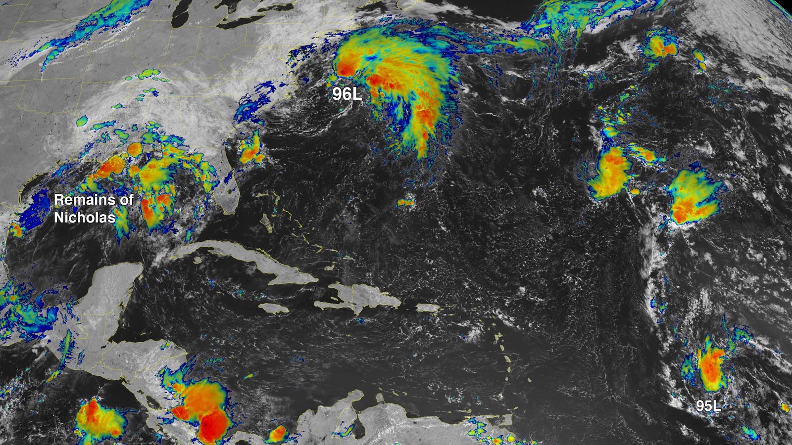
Disturbance 96L off coast of North Carolina
An area of disturbed weather, designated 96L, was about 150 miles northeast of the North Carolina Outer Banks early Friday afternoon, moving northeast at about 15 mph. Satellite imagery showed that 96L had a broad and elongated circulation, but no well-organized surface circulation. The system’s heavy thunderstorm activity was relatively modest, and displaced to the northeast of the center by high wind shear of 15-25 knots caused by upper-level winds out of the southwest.
96L has decent model support for development through Saturday night as it moves northeast at 15 mph, remaining a few hundred miles off the U.S. East Coast. Conditions are marginally favorable for development, with sea surface temperatures around 28 degrees Celsius (82°F), a moist mid-level atmosphere with a relative humidity around 70%, and moderate to high wind shear of 15-25 knots.
By Saturday night, 96L is expected to cross beyond the northern boundary of the Gulf Stream, where waters are cooler than 25 degrees Celsius (77°F). Wind shear will also increase to 30-40 knots, ending 96L’s chances of becoming a named storm. Steering currents favor a track a few hundred miles offshore from the Canadian Maritime Provinces, and 96L is expected to transition to a powerful extratropical storm that could bring 40-mph winds and rains of one to two inches to southeastern Newfoundland on Sunday. Steering currents are expected to collapse on Monday, resulting in 96L’s moving slowly and erratically a few hundred miles southeast of Newfoundland for multiple days. In its 8 a.m. EDT Friday Tropical Weather Outlook, the National Hurricane Center gave 96L 2-day and 5-day odds of development of 70%. The next name on the Atlantic list of storms is Odette.
Little change to 95L in the central tropical Atlantic
A tropical wave in the central tropical Atlantic, midway between the Lesser Antilles and the Cabo Verde Islands at 8 a.m. EDT Friday morning, was headed west to west-northwest at 15-20 mph. Satellite imagery showed that 95L was more organized than on Thursday, with a better-defined circulation, but the system had a relatively meager area of heavy thunderstorms and appeared to be struggling with dry air.
95L, with favorable conditions for development expected though the weekend, has modest model support for development. From Friday through Sunday, the disturbance will have sea surface temperatures near 28-28.5 degrees Celsius (82-83°F), mostly moderate wind shear of 10-20 knots, and a moderately moist atmosphere with a mid-level relative humidity of 55-65%. These conditions are expected to allow the system to develop into a tropical depression by Sunday. However, 95L is predicted to face a major obstacle to further intensification by Monday night, when it reaches the Leeward Islands, as a result of a large upper-level trough of low pressure. This trough is predicted to have high wind shear and dry air, and many model forecasts have 95L being destroyed when it encounters the trough. In its 8 a.m. EDT Friday Tropical Weather Outlook, the NHC decreased 95L’s 2-day and 5-day odds of development to 60% and 70%, respectively – a drop of 10% compared to Thursday’s odds. The next name on the Atlantic list of storms after Odette is Peter. The first hurricane hunter mission into 95L is scheduled for Sunday morning.
Bob Henson contributed to this post.
Website visitors can comment on “Eye on the Storm” posts. Please read our Comments Policy prior to posting. Comments are generally open for 30 days from date posted. Sign up to receive email announcements of new postings here. Twitter: @DrJeffMasters and @bhensonweather
Source link