What’s changed since yesterday
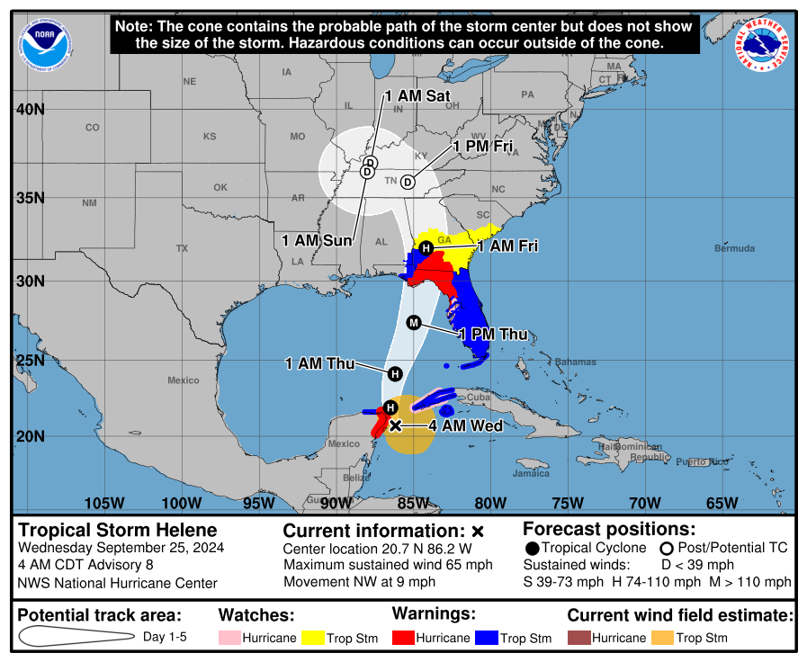
- Helene’s forecast intensity as it approaches Florida has been increased a bit, with risk for further increase in the intensity forecast today. Folks between Port St. Joe and Cedar Key should be preparing for major hurricane impacts.
- Hurricane Warnings extend into Georgia, a good bit beyond Valdosta. Tropical Storm Warnings now cover virtually the entire Florida Peninsula. Tropical Storm Watches extend into central Georgia and much of southeastern South Carolina.
- Helene’s track and surge forecast is relatively unchanged.
- The interior rainfall forecast has escalated, and there is growing risk of a potentially damaging, catastrophic flash flooding event from northeast Georgia into western North Carolina, including Asheville.
Not a whole lot has changed since yesterday. It’s nice to have a consistent forecast, but this is certainly turning into quite a serious situation for the eastern Florida Panhandle and Big Bend. Again, the minimum you should expect right now is an Idalia-type impact. For many, if not most places between Apalachee Bay and Tampa, this will probably be a worse impact than Idalia. Current surge forecasts continue to suggest impacts at or above Idalia. This surge forecast is virtually unchanged from 12 hours ago.
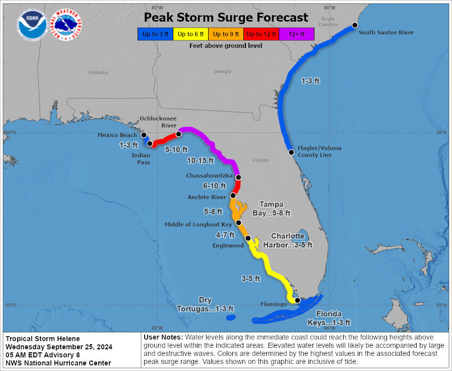
There’s honestly not a whole lot that needs to be said here with respect to the Florida coast between Cedar Key and Apalachee Bay: This has a decent chance to be worse than Idalia was and you should be closely following the advice of local officials.
The track forecast isn’t entirely locked down, but it’s close to it right now. There are still a handful of model data points suggesting a track slightly farther east than currently shown by the majority of tropical models and the official NHC forecast. This won’t hit Tampa directly, but a track closer to Cedar Key or Steinhatchee is possible, a Nature Coast/Big Bend hit more than an Apalachee Bay hit. This is why we encourage everyone from Port St. Joe to Homosassa or Clearwater to prepare for a significant hurricane hit, be it via surge, wind, or both.
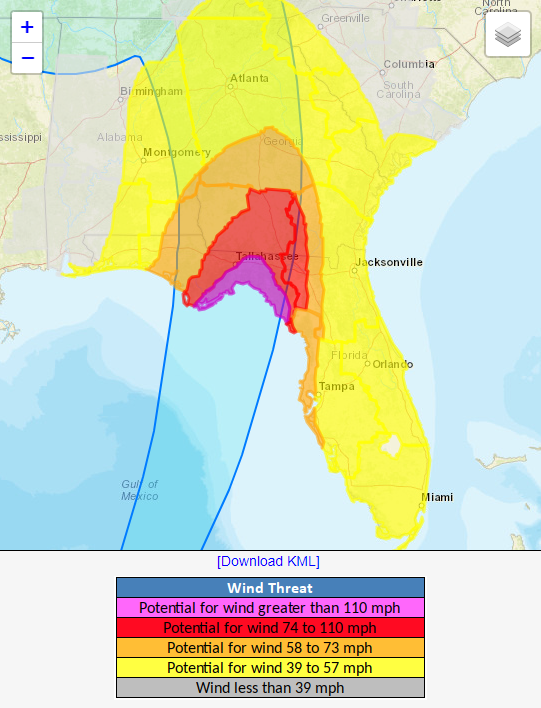
It’s also important to note how deep into Georgia hurricane-force winds are expected to go. That takes them close to Albany, GA and about halfway to Macon. Tropical storm force winds are expected to extend north of Macon to metro Atlanta and into South Carolina. This will almost certainly cause widespread power outages, and folks should be prepared to be without power for at least a few days.
Here is a list of major cities and their maximum wind gust forecasts from the NWS Point and Click forecasts as of Wednesday morning. These are likely to change:
Florida
Tallahassee: 63 mph
Cedar Key: 80 mph
Apalachicola: 77 mph
Panama City: 54 mph
Clearwater: 60 mph
Tampa: 59 mph
Sarasota: 72 mph
Fort Myers: 57 mph
Naples: 56 mph
Orlando: 49 mph
Jacksonville: 63 mph
Gainesville: 56 mph
Key West: 44 mph
Elsewhere
Valdosta: 57 mph
Albany, GA: 68 mph
Macon: 92 mph
Atlanta: 56 mph
Savannah: 39 mph
Athens: 75 mph
Augusta: 46 mph
Charleston: 37 mph
Columbia: 41 mph
Greenville: 48 mph
Spartanburg: 43 mph
Charlotte: 41 mph
Asheville: 51 mph
A major, potentially catastrophic flooding event possible in the Appalachians
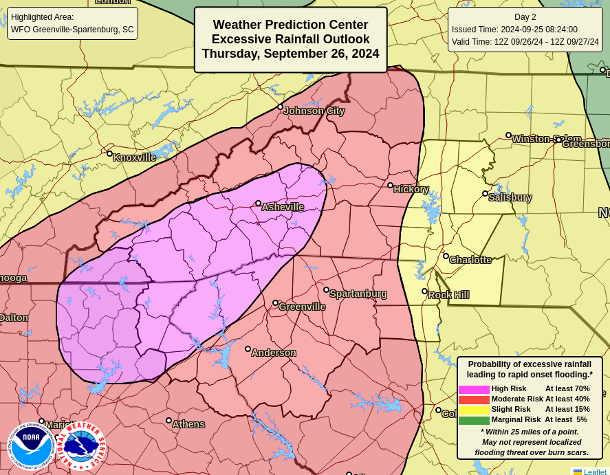
I want to focus on one element of this storm that is now coming into focus and becoming very serious: The risk of significant, possibly catastrophic flash flooding in the Appalachians from north Georgia into North Carolina.
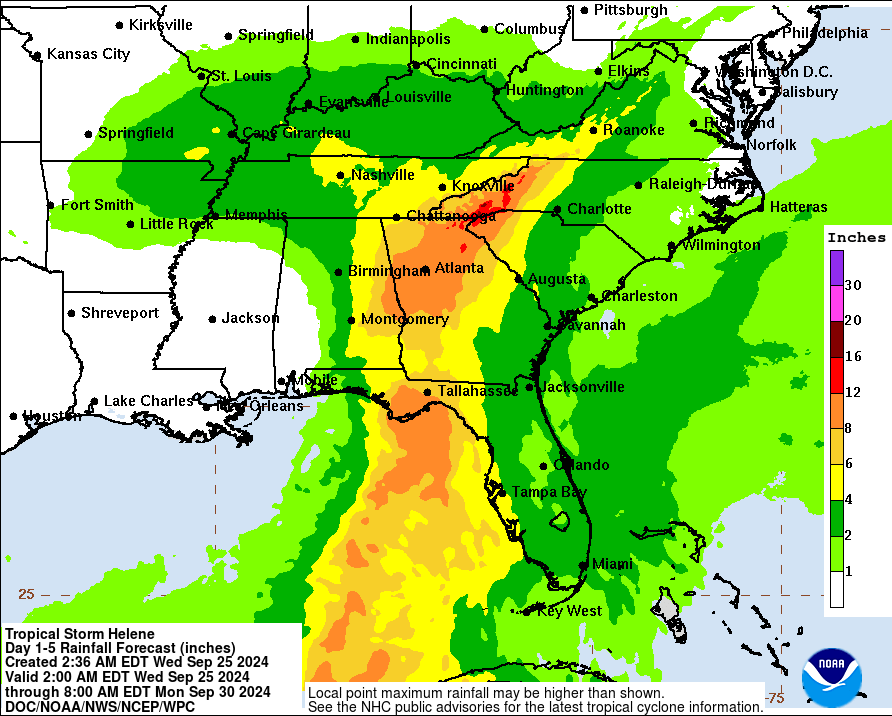
A high risk of flooding has been issued for some of those areas by the Weather Prediction Center, which historically has correlated to extensive, significant damage.

This is a historically favorable setup for major rainfall in this region, and there’s no reason to believe this forecast is incorrect. So for anyone in those affected areas and even in the red moderate risk areas surrounding the high risk, it is important to be prepared to take immediate action in the case of flooding or landslides. Please heed the advice of local officials. It is possible that the damage and problems from the inland flooding will be equally as bad as the surge issues at the coast.
Helene is going to be a complex, very difficult storm with multiple different concerns along the way. We’ll keep you posted as best we can through the event, but please also stick with trusted local sources for the latest and most relevant information for your neighborhood. We’ll update this post through the day.
Source link


