Don’t be distracted by Peter, Rose, and the remains of Odette in the Atlantic. These storms are all weak and pose a minimal threat to any land areas. The main story: a tropical wave designated 98L in the eastern Atlantic, which is expected to become Tropical Storm Sam later this week. It could threaten the Caribbean by the middle of next week.
Disturbance 98L the one to watch
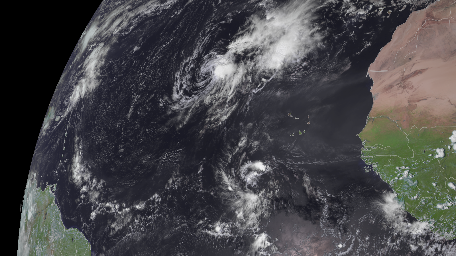
In the eastern Atlantic a few hundred miles southwest of the Cabo Verde Islands lies a tropical wave designated 98L by the National Hurricane Center (NHC). Satellite images on Tuesday afternoon showed 98L with a pronounced spin at mid-levels of the atmosphere, but no sign of a surface circulation, and few heavy thunderstorms. The wave was moving westward at 10-15 mph.
98L has strong model support for development, and conditions appear quite favorable for it to intensify throughout the week. Wind shear is predicted to be light to moderate, sea surface temperatures (SSTs) will be at least 28 degrees Celsius (82°F), and the atmosphere is predicted to be moist, with a mid-level relative humidity of 60-70%. The system’s development will be slowed, though, by its close proximity to the equator (near 9°N), which will keep 98L from gaining much spin from the Earth’s rotation.


98L is predicted to track west to west-northwest at 10-15 mph this week, potentially making it a threat to the Lesser Antilles Islands in seven to 10 days. The future track will depend heavily on how quickly 98L develops, and how strong it gets. A stronger storm is more likely to track farther to the north and miss the Lesser Antilles; a weaker and slower-to-organize storm will track farther to the west and potentially enter the Caribbean. 98L’s future track will also depend upon the timing and strength of troughs of low pressure passing to the north next week, and possibly on how strong the remains of tropical storms Peter, Odette, and Rose are. Remains of these storms could create a weakness in the ridge of high pressure steering 98L, allowing it to track farther to the north and miss the Lesser Antilles.
The 0Z and 6Z Tuesday runs of the GFS and European model ensembles showed a potential threat to the Leeward Islands by the middle of next week, with the European model showing more of a threat. The GFS model has been trending more towards the European model solution in recent runs, though. In its tropical weather outlook issued at 8 a.m. EDT Tuesday, the NHC gave 98L 2-day and 5-day odds of development of 50% and 90%, respectively. The next name on the Atlantic list of storms is Sam.


Tropical Storm Peter bringing heavy rain showers to islands of northeastern Caribbean
Tropical Storm Peter was bringing heavy rain showers to the northern Leeward Islands, Virgin Islands, and Puerto Rico on Tuesday afternoon, where rainfall amounts of one to four inches were predicted over the next day. However, Peter is pulling away from the islands as it tracks west-northwest at 9 mph, and satellite images showed that Peter’s active weather was concentrated on its east side, keeping the heaviest rains over water. At 11 a.m. EDT Tuesday, Peter was centered about 140 miles northeast of San Juan, Puerto Rico. Top sustained winds were 40 mph, but the NHC discussion noted that Peter already may have weakened to a tropical depression, based on data from an Air Force hurricane hunter aircraft.
Peter’s woes were the result of relentless 25-to-30-knot southwesterly wind shear, combined with dry air. These hostile conditions are expected to persist this week, with the NHC calling for Peter to degenerate to a remnant low by Thursday.
Rose expected to be a ‘fish’ storm
In the eastern Atlantic, another minimal-strength tropical storm, Rose, had a satellite appearance very similar to Peter’s: an exposed low-level circulation center, with all of the heavy thunderstorm activity confined to the east side of the center because of high wind shear.
At 11 a.m. EDT Tuesday, Rose was about 925 miles west-northwest of the Cabo Verde Islands, moving northwest at 12 mph, with top sustained winds of 40 mph. This track is expected to continue for the next several days, taking Rose into the central tropical Atlantic, far from any land areas. So Rose is expected to be a “fish” storm – one concerning marine interests and not impacting land. High wind shear, dry air, and marginally warm waters should weaken Rose to a tropical depression by Tuesday night, and a remnant low by Friday.
The remains of Odette may rise again
The remnants of Tropical Storm Odette, declared post-tropical south of Nova Scotia on Saturday evening, could regroup later this week as a subtropical cyclone as they arc southeastward atop warmer waters in the central Atlantic, about 700 miles west-northwest of the Azores Islands. In that case, the name Odette would most likely be revived.
In its 8 a.m. EDT Tropical Weather Outlook, the NHC gave ex-Odette 2-day and 5-day odds of regeneration of 20% and 40%, respectively. By the end of the week, Odette is expected to move northward over colder waters and finally lose any of the tropical characteristics it could briefly reacquire.
Bob Henson contributed to this post.
Website visitors can comment on “Eye on the Storm” posts. Please read our Comments Policy prior to posting. Comments are generally open for 30 days from date posted. Sign up to receive email announcements of new postings here. Twitter: @DrJeffMasters and @bhensonweather
Source link