| Mesoscale Discussion 1285 | |
| < Previous MD Next MD > | |

|
|
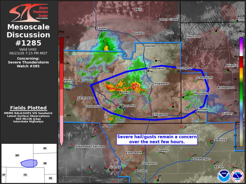
Mesoscale Discussion 1285 NWS Storm Prediction Center Norman OK 0722 PM CDT Tue Jun 23 2026 Areas affected...portions of southeastern Wyoming into extreme western Nebraska Concerning...Severe Thunderstorm Watch 385... Valid 240022Z - 240115Z The severe weather threat for Severe Thunderstorm Watch 385 continues. SUMMARY...Severe wind and hail will likely occur with any storms that manage to intensify and become sustained. DISCUSSION...Thunderstorms have struggled to become sustained east of I-25, possibly due to residual MLCINH over the warm sector. Nonetheless, MRMS mosaic radar imagery depicts deeper storm cores north of Laramie, WY, with up to 1 inch diameter hail likely falling. Should these storms manage to overcome the MLCINH and become sustained, larger severe hail (perhaps exceeding 2 inches in diameter) and severe gusts will become possible given 1500+ J/kg MLCAPE and 50-60 kts of effective bulk shear present. ..Squitieri.. 06/24/2026 ...Please see www.spc.noaa.gov for graphic product... ATTN...WFO...CYS... LAT...LON 41740643 42030549 42140456 42040349 41670332 41340345 41100400 41070474 41090534 41200587 41330620 41740643 |
|
|
Top/All Mesoscale Discussions/Forecast Products/Home |
|
Source link