| Mesoscale Discussion 1280 | |
| < Previous MD Next MD > | |

|
|
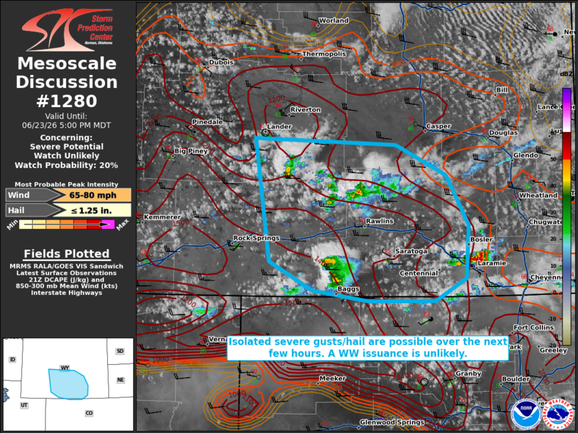
   Mesoscale Discussion 1280
   NWS Storm Prediction Center Norman OK
   0456 PM CDT Tue Jun 23 2026

   Areas affected...portions of central and southern Wyoming

   Concerning...Severe potential...Watch unlikely

   Valid 232156Z - 232300Z

   Probability of Watch Issuance...20 percent

   SUMMARY...A few instances of severe gusts or hail may accompany the
   stronger storms over the next few hours. A WW issuance is not
   anticipated.

   DISCUSSION...Visible satellite imagery and NLDN lightning data
   depict thunderstorms increasing in both coverage and intensity
   across portions of the Great Divide Basin. In this area, a deep and
   dry boundary layer is in place, as evidenced by 50 F T/Td spreads.
   21Z mesoanalysis depicts ample evaporative cooling potential (e.g.
   1500+ J/kg DCAPE) amid modest flow aloft, contributing to 30+ kts of
   effective bulk shear. High-based multicells and transient supercells
   will be the main modes of convection, with severe gusts possible. An
   instance or two of severe hail could also occur with the strongest
   storm cores. Nonetheless, the severe threat should remain relatively
   isolated, so a WW issuance is not expected.

   ..Squitieri/Smith.. 06/23/2026

   ...Please see www.spc.noaa.gov for graphic product...

   ATTN...WFO...BOU...CYS...RIW...GJT...

   LAT...LON   42760886 42690676 42340601 41780568 41200572 40950619
               40950716 41070801 41390865 42760886

   MOST PROBABLE PEAK WIND GUST...65-80 MPH
   MOST PROBABLE PEAK HAIL SIZE...UP TO 1.25 IN
|
|
|
Top/All Mesoscale Discussions/Forecast Products/Home |
|
Source link