| Mesoscale Discussion 1267 | |
| < Previous MD | |

|
|
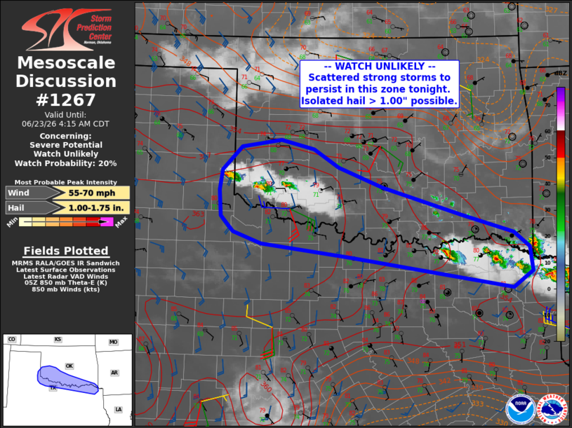
   Mesoscale Discussion 1267
   NWS Storm Prediction Center Norman OK
   1251 AM CDT Tue Jun 23 2026

   Areas affected...southern into southwest Oklahoma across the Red
   River into far northern Texas

   Concerning...Severe potential...Watch unlikely

   Valid 230551Z - 230915Z

   Probability of Watch Issuance...20 percent

   SUMMARY...Storms may increase in coverage across southern Oklahoma
   into parts of far northern Texas across the Red River. A few storms
   may become severe with locally large hail.

   DISCUSSION...Scattered storms have developed within a zone of weak
   theta-e advection at 850 mb, from southwest OK into northeast TX.
   Rich boundary layer moisture as well as overall strong instability
   exists in this region, along with effective deep-layer shear of
   35-40 kt. Area VWPs indicate 850 winds out of the south/southeast at
   around 25 kt, aiding lift across the warm advection zone. Models
   suggest low-level winds will veer and strengthen tonight, which may
   briefly increase ascent through about 10Z. Slow-moving cells with
   periodic hail cores and heavy rain are expected. Given high PWAT
   environment, localized strong downbursts may occur as well.

   ..Jewell/Gleason.. 06/23/2026

   ...Please see www.spc.noaa.gov for graphic product...

   ATTN...WFO...SHV...TSA...FWD...OUN...LUB...AMA...

   LAT...LON   33619781 33829949 34000001 34240023 34640027 34950021
               35309986 35419912 35289852 34999805 34689723 34269579
               33989482 33759454 33379448 33139485 33349608 33619781

   MOST PROBABLE PEAK WIND GUST...55-70 MPH
   MOST PROBABLE PEAK HAIL SIZE...1.00-1.75 IN
|
|
|
Top/All Mesoscale Discussions/Forecast Products/Home |
|
Source link