| Mesoscale Discussion 1252 | |
| < Previous MD | |

|
|
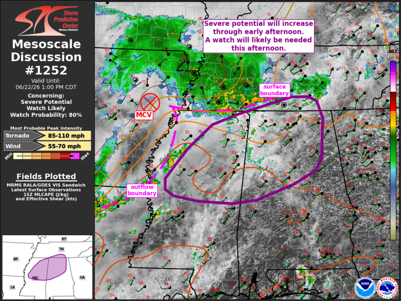
   Mesoscale Discussion 1252
   NWS Storm Prediction Center Norman OK
   1101 AM CDT Mon Jun 22 2026

   Areas affected...portions of northern and central MS/AL into
   southern Middle TN

   Concerning...Severe potential...Watch likely

   Valid 221601Z - 221800Z

   Probability of Watch Issuance...80 percent

   SUMMARY...Severe potential will increase across portions of northern
   and central Mississippi and Alabama into southern Middle Tennessee
   into early afternoon. Damaging wind gusts will be the main hazard,
   but a tornado or two also may occur. A watch will likely be needed
   by early afternoon.

   DISCUSSION...Airmass destabilization is occurring downstream from an
   MCV over eastern AR at midday. This MCV should continue moving
   eastward along a surface boundary sagging across western TN.
   Thunderstorms are ongoing along outflow from an overnight MCS near
   the MS River into northern LA. These storms are expected to
   gradually increase in intensity across MS over the next couple of
   hours. Filtered heating has allowed temperatures to warm into the
   80s amid a very moist boundary layer characterized by mid-70s
   dewpoints. While midlevel lapse rates will remain modest, MLCAPE
   should climb to around 1500-2500 J/kg through afternoon. The MCV
   will also provide enhanced westerly flow in conjunction with a 25-30
   kt southwesterly 850 mb low-level jet overspreading the TN Valley
   vicinity. This will support organized clusters, and perhaps some
   upscale development into a bowing segment across portions of the MCD
   area.

   Interestingly, RAP forecast soundings indicate some drier air above
   850 mb amid PW values near 2 inches. This moisture profile amid
   moderate to strong instability and modestly enhanced
   west/southwesterly flow suggests damaging wind gusts will be the
   primary hazard with convection through the afternoon. However, some
   enhancement of low-level SRH may accompany areas near the core of
   the MCV. As such, a tornado or two also could occur. A watch will
   likely be needed at some point early this afternoon, but timing
   remains a bit uncertain.

   ..Leitman/Hart.. 06/22/2026

   ...Please see www.spc.noaa.gov for graphic product...

   ATTN...WFO...OHX...BMX...HUN...MEG...JAN...

   LAT...LON   32758789 32658860 32708963 32839036 32989062 33259064
               33619035 34058996 34658923 34928844 35358682 35358631
               35238604 34798586 34238589 33788591 33478612 33158676
               32758789

   MOST PROBABLE PEAK TORNADO INTENSITY...85-110 MPH
   MOST PROBABLE PEAK WIND GUST...55-70 MPH
|
|
|
Top/All Mesoscale Discussions/Forecast Products/Home |
|
Source link