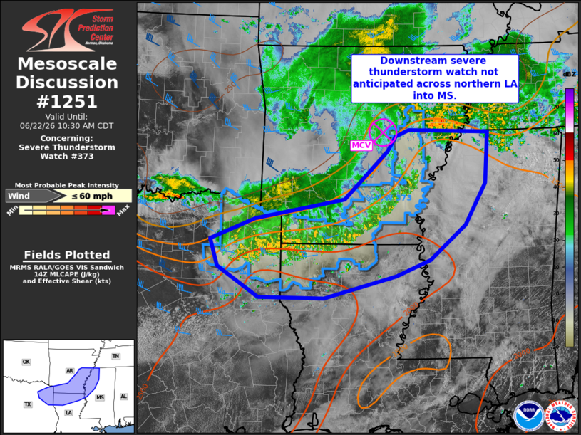
MD 1251 CONCERNING SEVERE THUNDERSTORM WATCH 373… FOR PORTIONS OF EASTERN AR…NORTHWEST MS…NORTHERN LA…AND NORTHEAST TX
Mesoscale Discussion 1251
NWS Storm Prediction Center Norman OK
0906 AM CDT Mon Jun 22 2026

Areas affected...portions of eastern AR...northwest MS...northern
LA...and northeast TX

Concerning...Severe Thunderstorm Watch 373...

Valid 221406Z - 221530Z

The severe weather threat for Severe Thunderstorm Watch 373
continues.

SUMMARY...Mainly sub-severe winds may persist with decaying MCS
moving across the ArkLaTex and Lower Mississippi Valley through the
morning hours. Overall severe potential is expected to remain low,
and a downstream watch is not expected.

DISCUSSION...Convection along the leading edge of a decaying MCS
across southeast AR into northern LA/northeast TX has diminished in
intensity over the past hour. A 37 kt measured gust was noted at
KPBF/Pine Bluff AR in the past 30-40 minutes, and measured severe
gusts have not be noted for 1-2 hours. As the convection continues
to percolate east/southeast the next few hours, gusty winds of this
caliber may occur. However, overall decreasing organization and
intensity of the weakening MCS is expected to continue and severe
potential will be limited. As the associated MCV over eastern AR
tracks eastward along a southward sagging surface boundary, some
severe potential could increase later this afternoon across parts of
MS, but severe potential should remain low the next few hours. As
such, a downstream severe thunderstorm watch is not expected at this
time.

..Leitman.. 06/22/2026

...Please see www.spc.noaa.gov for graphic product...

ATTN...WFO...MEG...JAN...LZK...SHV...FWD...

LAT...LON   35019136 34978968 34078976 33349019 32739093 32449164
            32069313 32069450 32609535 33079551 33459458 33809271
            34639182 34919164 35019136

MOST PROBABLE PEAK WIND GUST...UP TO 60 MPH
Source link