| Mesoscale Discussion 1238 | |
| < Previous MD | |

|
|
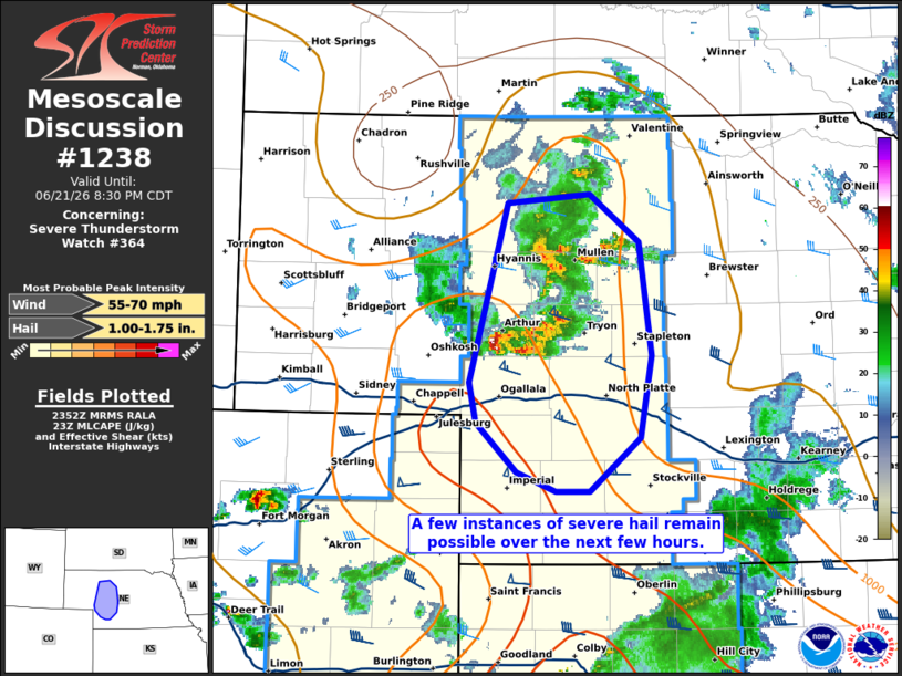
Mesoscale Discussion 1238 NWS Storm Prediction Center Norman OK 0655 PM CDT Sun Jun 21 2026 Areas affected...portions of western Nebraska Concerning...Severe Thunderstorm Watch 364... Valid 212355Z - 220130Z The severe weather threat for Severe Thunderstorm Watch 364 continues. SUMMARY...A few instances of severe hail and perhaps a severe gust remain possible with the stronger storms over the next few hours. DISCUSSION...MRMS mosaic radar imagery has shown an uptick in convective intensity with multicells across western NE over the past 1-2 hours. These storms are approaching an airmass characterized by 1500+ J/kg MLCAPE and 50 kts of effective bulk shear, which will continue to support a severe hail threat. A severe gust is also possible given the 8-9 C/km low-level lapse rates in place (per 23Z mesoanalysis). Nonetheless, the ongoing storms are approaching an area of increasing convective inhibition due to tropospheric overturning caused by earlier storms. It is unclear how long-lived the longer-term severe threat will be in NE given convective overturning. However, in the near term, a few instances of severe hail or a gust remain possible. ..Squitieri.. 06/21/2026 ...Please see www.spc.noaa.gov for graphic product... ATTN...WFO...LBF... LAT...LON 42410164 42470090 42160047 41390035 40850046 40480090 40480120 40610155 40950191 41220198 42410164 MOST PROBABLE PEAK WIND GUST...55-70 MPH MOST PROBABLE PEAK HAIL SIZE...1.00-1.75 IN |
|
|
Top/All Mesoscale Discussions/Forecast Products/Home |
|
Source link