| Mesoscale Discussion 1222 | |
| < Previous MD | |

|
|
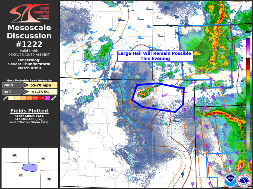
Mesoscale Discussion 1222 NWS Storm Prediction Center Norman OK 1130 PM CDT Sat Jun 20 2026 Areas affected...portions of the Nebraska Sandhills Concerning...Severe Thunderstorm Watch 360... Valid 210430Z - 210630Z The severe weather threat for Severe Thunderstorm Watch 360 continues. SUMMARY...Thunderstorms continue moving east across portions of north-central Nebraska this evening. Modest instability and strong shear should maintain the MCS structure, although weak low-level lapse rates should keep any severe threat rather isolated. DISCUSSION...A north-south linear MCS has organized across portions of north-central Nebraska this evening and will continue eastward into the morning hours. The overall environment remains kinematically favorable for thunderstorm organization (effective layer shear greater than 50 knots), although the thermodynamic environment remains modest at best with between 500 to 1000 J/kg of MUCAPE along the line of storms. Additionally, low-level lapse rates continue to weaken, with 0-3 kilometer lapse rates objectively analyzed to be around 3 C/km. Thus, despite the linear MCS's organization, the elevated nature of the individual thunderstorms and the weak low-level lapse rates should limit any severe wind potential to being isolated/sporadic in nature. ..Marsh.. 06/21/2026 ...Please see www.spc.noaa.gov for graphic product... ATTN...WFO...GID...LBF...UNR... LAT...LON 43000123 43010026 40710021 40660124 40990127 41260203 41970138 43000123 MOST PROBABLE PEAK WIND GUST...55-70 MPH MOST PROBABLE PEAK HAIL SIZE...UP TO 1.25 IN |
|
|
Top/All Mesoscale Discussions/Forecast Products/Home |
|
Source link