| Mesoscale Discussion 1221 | |
| < Previous MD Next MD > | |

|
|
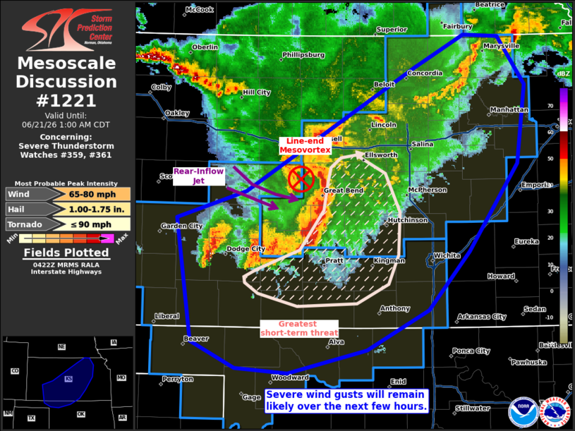
Mesoscale Discussion 1221 NWS Storm Prediction Center Norman OK 1124 PM CDT Sat Jun 20 2026 Areas affected...portions of western into central Kansas Concerning...Severe Thunderstorm Watch 359...361... Valid 210424Z - 210600Z The severe weather threat for Severe Thunderstorm Watch 359, 361 continues. SUMMARY...Severe gusts will remain a concern with the ongoing MCS for at least the next few hours. DISCUSSION...A mature cold-pool-driven MCS continues to propagate southeastward across western into central KS, with several recent measured severe gusts noted. Recent KICT inbound velocity data shows that a pronounced rear-inflow jet persists with this MCS, as well as a book-end/line-end mesovortex on its northern flank. Furthermore, this MCS will continue to progress southeastward amid a highly sheared and buoyant airmass, characterized by 50 kts of effective bulk shear (oriented roughly normal to the MCS leading line) and 2000+ J/kg MLCAPE, driven by 8+ C/km mid-level lapse rates. Given the highly organized storm structure and favorable ambient supporting environment, severe gusts will likely continue with this MCS for at least a few more hours. ..Squitieri.. 06/21/2026 ...Please see www.spc.noaa.gov for graphic product... ATTN...WFO...OAX...TOP...ICT...OUN...GID...DDC...AMA... LAT...LON 38120065 38409974 39679754 40019690 39989644 39489610 38679621 37789685 37189738 36779817 36539919 36579987 36840045 38120065 MOST PROBABLE PEAK TORNADO INTENSITY...UP TO 90 MPH MOST PROBABLE PEAK WIND GUST...65-80 MPH MOST PROBABLE PEAK HAIL SIZE...1.00-1.75 IN |
|
|
Top/All Mesoscale Discussions/Forecast Products/Home |
|
Source link