| Mesoscale Discussion 1187 | |
| < Previous MD Next MD > | |

|
|
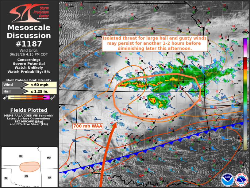
   Mesoscale Discussion 1187
   NWS Storm Prediction Center Norman OK
   0251 PM CDT Thu Jun 18 2026

   Areas affected...portions of the south-central Great Plains

   Concerning...Severe potential...Watch unlikely

   Valid 181951Z - 182115Z

   Probability of Watch Issuance...5 percent

   SUMMARY...An isolated threat for large hail and gusty winds may
   persist for another couple of hours before diminishing later this
   afternoon/evening.

   DISCUSSION...As of 1930 UTC, persistent elevated convection remained
   ongoing across portions of southern Kansas and northern Oklahoma.
   This activity has produced isolated reports of 1.00-1.25" hail and
   damaging wind gusts over the past several hours. Continued
   low-to-mid tropospheric warm air advection (centered around 700 mb)
   atop a low-level frontal inversion is sustaining these storms, with
   latest objective analysis indicating the presence of 1000-2000 J/kg
   MLCAPE. Effective shear of 40-50 kts and elongated hodographs above
   the frontal inversion may continue to support occasional elevated
   supercells capable of isolated large hail; although, relatively weak
   mid-level lapse rates (generally less than 7 C/km) will largely
   limit this threat. Occasional strong/damaging wind gusts may also
   accompany these storms. This risk should then gradually diminish
   with time through this afternoon and evening. Watch issuance is not
   expected owing to the limited severe coverage/magnitude.

   ..Chalmers/Hart.. 06/18/2026

   ...Please see www.spc.noaa.gov for graphic product...

   ATTN...WFO...SGF...TSA...ICT...OUN...DDC...

   LAT...LON   36919849 37219832 37349811 37449771 37589641 37619576
               37519525 37459501 37089478 36749482 36449523 36199587
               36079656 36119733 36269814 36519841 36919849

   MOST PROBABLE PEAK WIND GUST...UP TO 60 MPH
   MOST PROBABLE PEAK HAIL SIZE...UP TO 1.25 IN
|
|
|
Top/All Mesoscale Discussions/Forecast Products/Home |
|
Source link