| Mesoscale Discussion 1133 | |
| < Previous MD Next MD > | |

|
|
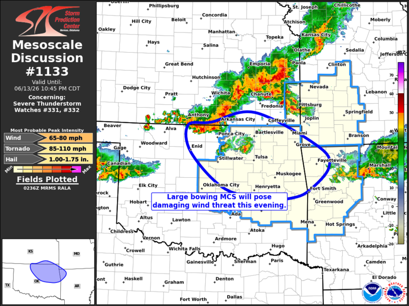
Mesoscale Discussion 1133 NWS Storm Prediction Center Norman OK 0939 PM CDT Sat Jun 13 2026 Areas affected...Northeast Oklahoma and Northwest Arkansas Concerning...Severe Thunderstorm Watch 331...332... Valid 140239Z - 140345Z The severe weather threat for Severe Thunderstorm Watch 331, 332 continues. SUMMARY...Bowing line of storms will move into north-central Oklahoma this evening, with the risk of damaging winds. A new severe thunderstorm watch has just been issued. DISCUSSION...A large bowing MCS has evolved across southeast central KS, with 50+ knot wind gusts being recently reported at multiple ASOS sites. This activity is expected to surge southeastward across north-central and northeast OK along and south of a remnant outflow boundary. Ample CAPE/moisture and increasing mesoscale organization of the bow could maintain a severe risk as far east as northwest AR. ..Hart/Gleason.. 06/14/2026 ...Please see www.spc.noaa.gov for graphic product... ATTN...WFO...SGF...TSA...ICT...OUN... LAT...LON 37069730 37319596 36469408 35969379 35439437 35249486 35229556 35459685 36329788 36989798 37069730 MOST PROBABLE PEAK TORNADO INTENSITY...85-110 MPH MOST PROBABLE PEAK WIND GUST...65-80 MPH MOST PROBABLE PEAK HAIL SIZE...1.00-1.75 IN |
|
|
Top/All Mesoscale Discussions/Forecast Products/Home |
|
Source link