| Mesoscale Discussion 1132 | |
| < Previous MD | |

|
|
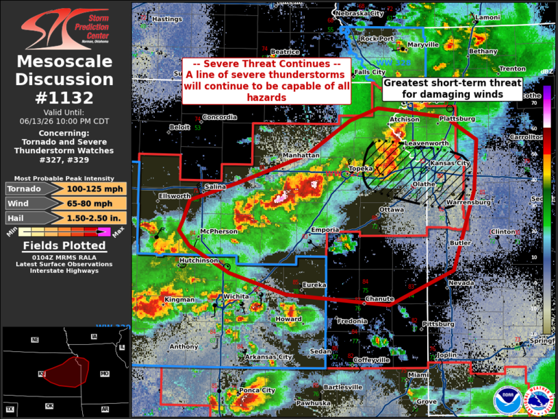
Mesoscale Discussion 1132 NWS Storm Prediction Center Norman OK 0805 PM CDT Sat Jun 13 2026 Areas affected...Northeastern Kansas into Western Missouri Concerning...Tornado and Severe Thunderstorm Watches 327...329... Valid 140105Z - 140300Z The severe weather threat for Tornado and Severe Thunderstorm Watches 327, 329 continues. SUMMARY...The severe threat for WW 327 and WW 329 continues into this evening. While all hazards (including tornadoes) remain possible, the threat is transitioning to primarily damaging straight-line winds. DISCUSSION...A cluster of supercells has grown upscale and completed the transition to a primarily linear convective mode across much of northeastern Kansas, where wind gusts in the outflow have been measured in the 60-70 MPH range. This will be the primary hazard heading into the early evening hours, with a focused corridor of short-term damaging wind threat evident in the vicinity of Kansas City. Strong deep layer shear and increasing hodograph curvature with the onset of the nocturnal low-level jet will continue to support a tornado threat this evening and after sunset, but the overall messiness and linear nature of the current convection leaves uncertainty on where and when such a threat could materialize. Still, line embedded mesocyclones and tornadoes are still possible into the early evening. A downstream severe thunderstorm watch will be needed later this evening. ..Halbert.. 06/14/2026 ...Please see www.spc.noaa.gov for graphic product... ATTN...WFO...SGF...EAX...TOP...ICT... LAT...LON 38749778 38959711 39249622 39599563 39729526 39629435 39399393 38859397 38029426 37669511 37779649 37999724 38269779 38429792 38539787 38749778 MOST PROBABLE PEAK TORNADO INTENSITY...100-125 MPH MOST PROBABLE PEAK WIND GUST...65-80 MPH MOST PROBABLE PEAK HAIL SIZE...1.50-2.50 IN |
|
|
Top/All Mesoscale Discussions/Forecast Products/Home |
|
Source link