| Mesoscale Discussion 1126 | |
| < Previous MD Next MD > | |

|
|
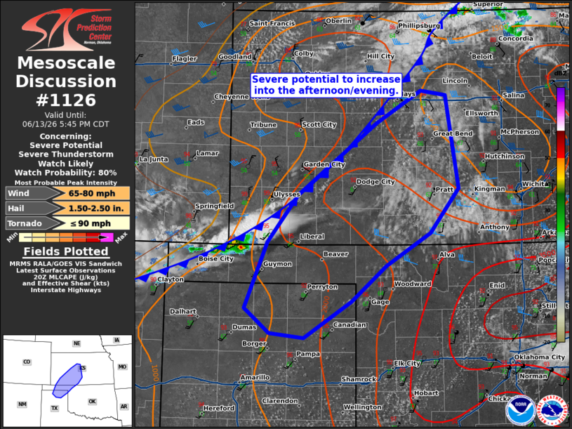
   Mesoscale Discussion 1126
   NWS Storm Prediction Center Norman OK
   0341 PM CDT Sat Jun 13 2026

   Areas affected...portions of southern/western Kansas into portions
   of the Oklahoma/Texas Panhandle

   Concerning...Severe potential...Severe Thunderstorm Watch likely

   Valid 132041Z - 132245Z

   Probability of Watch Issuance...80 percent

   SUMMARY...Thunderstorm activity is expected to develop along the
   front and spread eastward with time through the evening. Threats
   will include damaging wind and large hail.

   DISCUSSION...Thunderstorm activity is expected to develop along a
   southward moving cold front this afternoon/evening across portions
   of western Kansas into the Oklahoma/Texas Panhandles. Initial
   activity has begun to develop across the far western Panhandles
   where profiles are deeply mixed. As a result initial activity has
   struggled to establish but lightning has developed over the last
   30-45 minutes.

   Ahead of the front, steep low to mid-level lapse rates (7-8 C/km)
   are spreading eastward with temperatures in the upper 80s to 90s.
   Warming temperatures and dew points in the mid 60s to 70s have
   yielded MLCAPE around 2500-3000 J/kg. Initial activity will likely
   be supercellular with potential for large hail and damaging wind
   before tendency to quickly grow upscale with the southward moving
   front. This will likely shift the main threat to become damaging
   wind. A watch will likely be needed to cover this potential.

   ..Thornton/Mosier.. 06/13/2026

   ...Please see www.spc.noaa.gov for graphic product...

   ATTN...WFO...ICT...OUN...DDC...AMA...

   LAT...LON   37020141 37640092 38559966 38989894 38919853 37729833
               37149879 36729950 36260007 35800083 35860137 36180178
               37020141

   MOST PROBABLE PEAK TORNADO INTENSITY...UP TO 90 MPH
   MOST PROBABLE PEAK WIND GUST...65-80 MPH
   MOST PROBABLE PEAK HAIL SIZE...1.50-2.50 IN
|
|
|
Top/All Mesoscale Discussions/Forecast Products/Home |
|
Source link