| Mesoscale Discussion 1085 | |
| < Previous MD | |

|
|
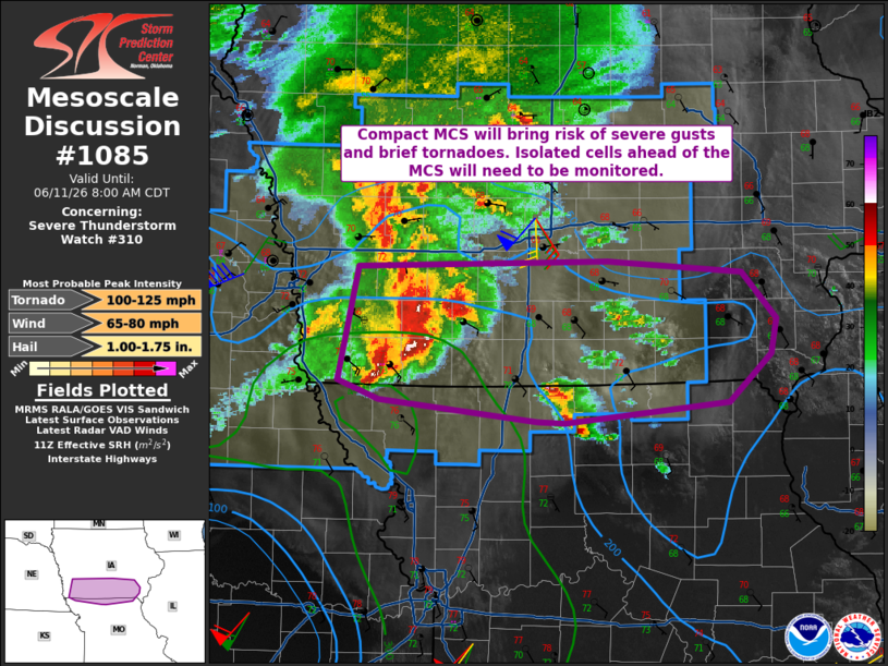
Mesoscale Discussion 1085 NWS Storm Prediction Center Norman OK 0633 AM CDT Thu Jun 11 2026 Areas affected...Southern Iowa and far northern Missouri Concerning...Severe Thunderstorm Watch 310... Valid 111133Z - 111300Z The severe weather threat for Severe Thunderstorm Watch 310 continues. SUMMARY...The threat for 60-80 mph winds will continue in southern Iowa. Brief tornadoes associated with the MCS will also be a concern. With discrete development ahead of the MCS possible, trends will need to be monitored for a potentially greater tornado threat. DISCUSSION...A compact MCS with a history of 60-80 mph winds and a couple of brief tornadoes continues east within southern Iowa. Ahead of this MCS, weak thunderstorm development has been noted in south-central Iowa. The primary concern this morning will continue to be severe/damaging winds as the downstream environment begins to further destabilize. A secondary concern that needs to be monitored is the potential for stronger discrete development ahead of the MCS near the surface boundary. The low-level jet core is expected to move into more of central/eastern Iowa this morning. This could lead to a greater tornado risk if discrete storms can form/mature. ..Wendt.. 06/11/2026 ...Please see www.spc.noaa.gov for graphic product... ATTN...WFO...DVN...DMX...EAX...OAX... LAT...LON 40609549 41399531 41429306 41359184 41039154 40799159 40459197 40329344 40329369 40479512 40609549 MOST PROBABLE PEAK TORNADO INTENSITY...100-125 MPH MOST PROBABLE PEAK WIND GUST...65-80 MPH MOST PROBABLE PEAK HAIL SIZE...1.00-1.75 IN |
|
|
Top/All Mesoscale Discussions/Forecast Products/Home |
|
Source link