| Mesoscale Discussion 1080 | |
| < Previous MD | |

|
|
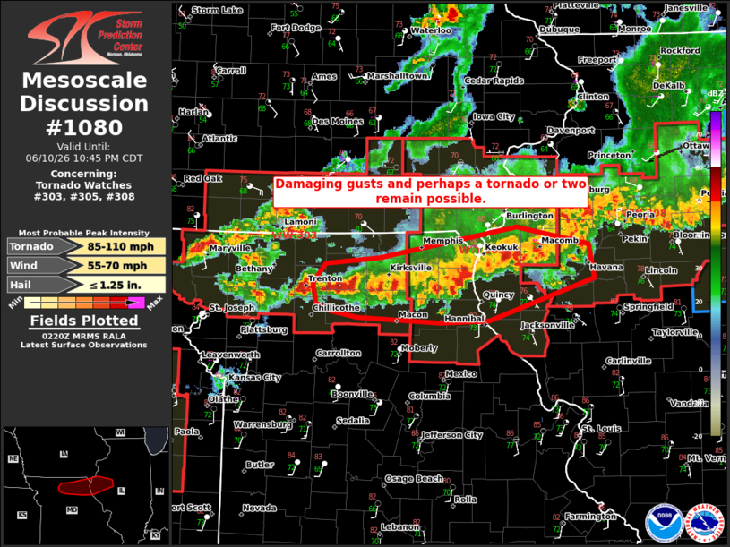
Mesoscale Discussion 1080 NWS Storm Prediction Center Norman OK 0922 PM CDT Wed Jun 10 2026 Areas affected...portions of northern Missouri and western Illinois Concerning...Tornado Watch 303...305...308... Valid 110222Z - 110345Z The severe weather threat for Tornado Watch 303, 305, 308 continues. SUMMARY...Damaging gusts and a brief tornado remain possible with strong to severe storms this evening. Storms are mostly behind the outflow, but the environment near the boundary still supports some risk. DISCUSSION...Across parts of northern MO and western IL, initial supercells have coalesced into several clusters along and north of an east-west oriented outflow boundary across northern MO and northwest IL. The environment south of the boundary remains moderately unstable with MLCAPE of 2000-2500 J/kg. This is supporting a risk for stronger thunderstorms within the ongoing clusters. Deep-layer shear, aided by an observed 50 kt low-level jet, is also supportive of bowing or occasional embedded supercell features. Given the strong buoyancy and shear, some potential for primarily damaging gusts and perhaps a brief tornado remains this evening. With time, the increase in nocturnal inhibition and the tendency for outflow to undercut these storms should end the severe threat. ..Lyons.. 06/11/2026 ...Please see www.spc.noaa.gov for graphic product... ATTN...WFO...ILX...LSX...DVN...EAX... LAT...LON 39829329 39899349 40099352 40289337 40349268 40649096 40489004 40148998 39749130 39729192 39769297 39829329 MOST PROBABLE PEAK TORNADO INTENSITY...85-110 MPH MOST PROBABLE PEAK WIND GUST...55-70 MPH MOST PROBABLE PEAK HAIL SIZE...UP TO 1.25 IN |
|
|
Top/All Mesoscale Discussions/Forecast Products/Home |
|
Source link